
This guide will help you plan a multi-day, unsupported thru-hike on a 102km stage of the Transcaucasian Trail, passing through the high volcanic plateaus, seasonal shepherd camps, shimmering alpine lakes, and lush forests of Samtskhe-Javakheti in southern Georgia. Here you’ll find practical information and trail notes, plus links to interactive maps and downloadable GPS data to help navigate the route.
Quick Facts
- Distance
- 102km / 63mi(+ optional 30km / 19mi extension to the Armenian border)
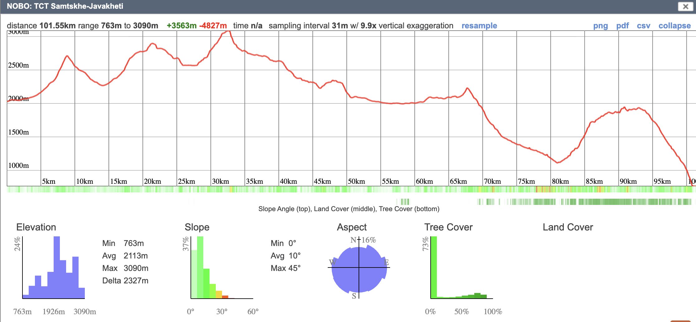
- Elevation gain
- Northbound: +3,563m / +11,690ftSouthbound: +4,827m / +15,837ft
- Elevation loss
- Northbound: −4,827m / −15,837ftSouthbound: −3,562m / −11,690ft
- Minimum elevation
- 763m / 2,503ft
- Maximum elevation
- 3,091m / 10,141ft
- Average elevation
- 2,113m / 6,932ft
- Status
- Open
- Marking type
- Partially blazed
- Emergency services
- 112
Northbound Elevation Profile
Southbound Elevation Profile
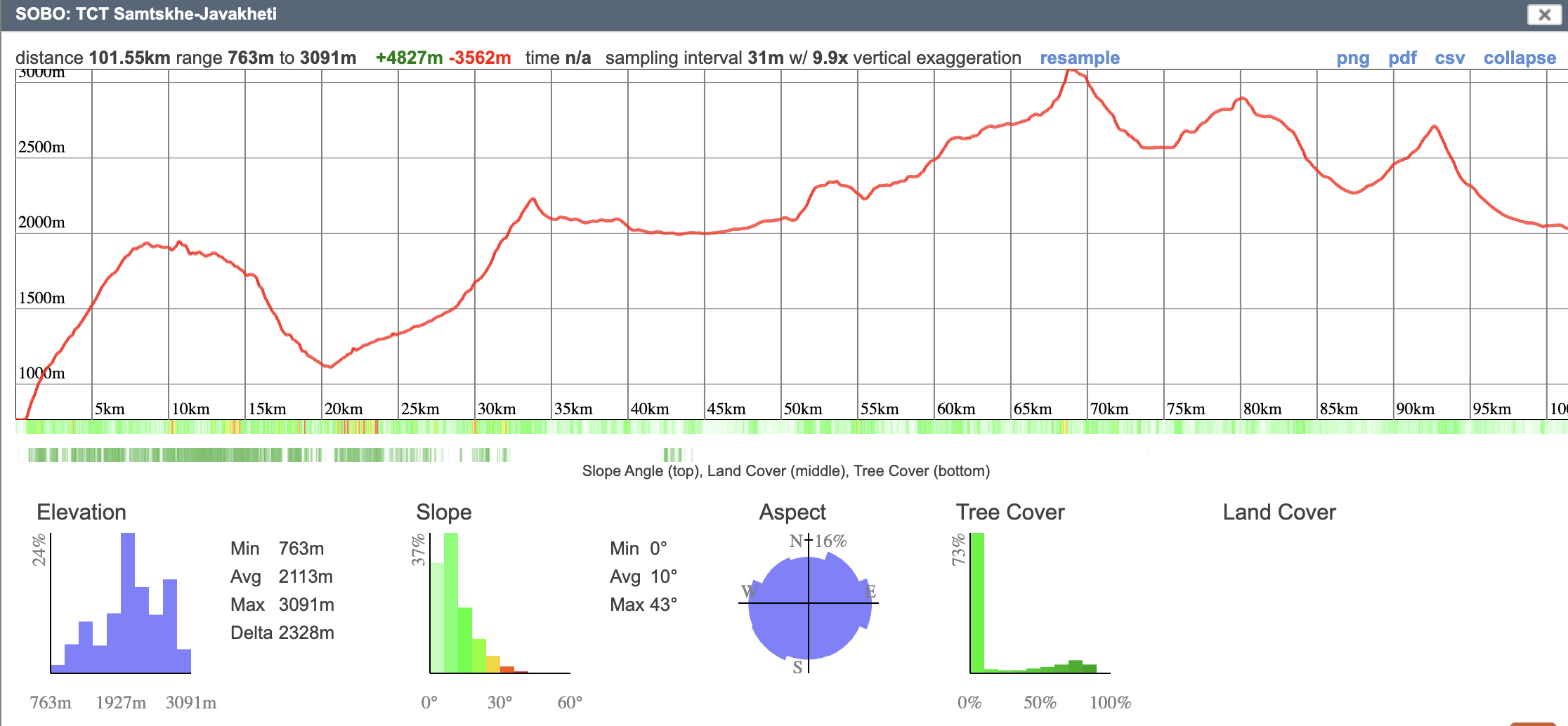
The route crosses the Abul-Samsari volcanic range, a high plateau of cinder cones, calderas, and a string of alpine lakes. The terrain underfoot shifts often — grassy 4×4 tracks, open meadow, boulder fields you’ll rock-hop across — and on a clear day the views run for kilometers in every direction. It’s spectacular country, and on the right afternoon it feels otherworldly. Cultural highlights include the Bronze Age megalithic ruins of Abuli Fortress, the distinctive grass roofs of Javakheti villages, and the famous Georgian spa town of Borjomi. Villages in Javakheti are predominantly ethnic Armenian; many of the shepherds you’ll meet in the highlands are Azerbaijani. After the pass between Tabatskuri and Didi Mitarbi, the landscape changes abruptly: the open plateau gives way to thick forest, and the trail descends toward the popular tourist town of Borjomi.
This section is unsupported. Camping is required, and hikers need to be self-sufficient with food for several days at a time. The first guesthouse since Gandzani sits at Lake Tabatskuri, roughly halfway through. The lakes along the route make exceptional campsites.
Hikers need to be sure-footed across boulder fields and confident route-finding in open terrain. In clear weather, the plateau is straightforward to navigate by sight. In fog or storms, it goes featureless fast. Carry a charged phone and extra battery pack, a downloaded GPX track, and ideally a paper map and compass (you can print maps from the interactive CalTopo maps).
The crux is Samsari Pass, a steep scree climb that demands careful footwork. If snow lingers on the north face, weather is poor, or you’re uncertain on scree, take the lowland alternate described in the stage notes. Read that page before you commit.
The trail is blazed in white and yellow from Gandzani to Samsari Pass; markings get sporadic after that. The Samtskhe-Javakheti DMO blazed these routes several years ago. They provide helpful reassurance, but in general you should treat the blazes as a supplement, not your primary navigation aid.
In summer, seasonal shepherd camps populate the highlands. Expect large flocks and livestock guardian dogs. Encounters are part of hiking this section — see Hazards for the protocol we recommend. Carry trekking poles.
In the stage notes, we’ve provided stage breakdowns for a five-day hike with suggested camping spots, but there’s always the option to go slower or faster according to your pace and preferred method of travel. Enjoy and hike your own hike!
Important Disclaimer
The TCTA strives to provide accurate, current information as to trail conditions and the trail route. However, actual trail conditions may be different, and such information may not be accurate or complete. Trail users are urged to consider all the information available from other sources and to heed local advice when available. Trail users are ultimately responsible for all decisions as to the trail routes, trail conditions, weather, and safety.
In addition to the hazards posed by steep terrain and mountain weather, hikers should be prepared for difficult route-finding and challenging trail conditions, the possibility of washed-out bridges and dangerous river crossings in high water, aggressive dogs guarding sheep and cattle, giant hogweed, and frequent summer thunderstorms with extremely intensive periods of lightning. Access to emergency medical care and search and rescue is not always available.
