
Gamarvan – Abrikh
Gamarvan – Abrikh (24.26 km / 15.07 mi)
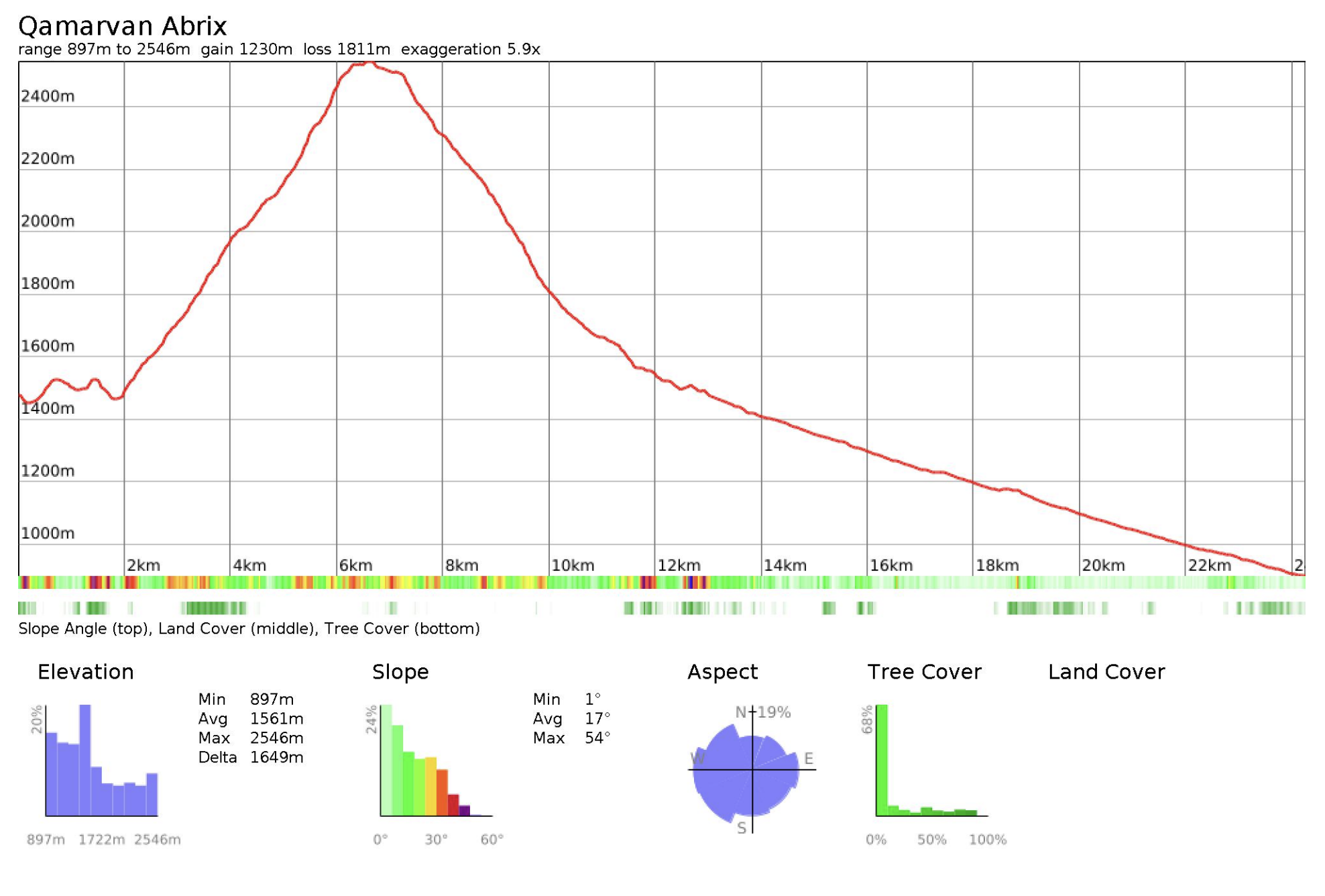
Distance: 24.26 km / 15.07 mi
Elevation gain: +1230 m / +4,035 ft
Elevation loss: –1811 m / –5,942 ft
Minimum elevation: 897 m / 2,943 ft
Maximum elevation: 2546 m / 8,353 ft
This stage climbs out of the upper Gamarvan valley through steep forest and into open rocky alpine terrain below the peak of Keçəldağ, then descends back toward the river system leading to Abrikh. It combines a strong mountain crossing with a long river valley exit, and includes some of the more changeable terrain in the section. Depending on your itinerary, you can either remain fully in backcountry mode or descend into the villages. The upper half is scenic and exposed, while the lower half is more defined by riverbed travel, flood damage, and route changes caused by weather.
Trail conditions
This stage is a mix of steep forest paths, grazing tracks, rocky alpine ground, and riverbed travel. There is no formal maintenance, and conditions can change significantly from season to season, especially in the lower valley. Footfall is generally very low, apart from local pastoral use in summer.
Predictable issues include washed-out sections near the river, unstable or rocky ground where flood damage has erased the original line, and faint paths in the alpine zone where multiple livestock tracks split and rejoin. The initial connection from the riverbed to the main trail above Gamarvan may be damaged by floods and can require short, awkward movement over rocky ground to regain the line. In spring and after heavy rain, this stage becomes substantially harder due to high water, mud, and erosion. In summer and early autumn, the route is generally more manageable, though the river corridor remains variable.
Water
There is a spring near the pasture area below Keçəldağ, slightly off the main line. Because much of the route passes through grazing terrain and flood-prone drainage, all natural water sources should be treated. In dry late-summer periods, smaller side sources may dry up.
Trail access
The stage begins in Gamarvan, and ends in Abrikh (depending on whether you choose to descend fully), both villages accessible by road. As with the previous stage, there is again an option to remain more in backcountry mode rather than going into the village itself.
The upper mountain crossing has no quick exit, and once you commit to the descent toward the river valley, movement is largely dictated by the drainage. The long riverbed section also forms the main approach toward Abrikh, with one notable junction where a side trail leads toward Abdallı. This junction offers the most significant route split on the stage.
Navigational Notes
Navigation is moderately complex in the upper half and highly condition-dependent in the lower half. GPS tracks are essential, but even with them, hikers should expect local deviations. The river corridor in particular should be treated as a dynamic environment rather than a fixed trail.
