
Ilisu – Mamrukh
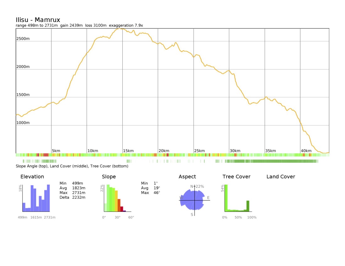
Ilisu – Mamrukh: 44 km, +2795m / -3460m (E → W)
The Ilisu–Mamrukh trail is a rugged and demanding, potentially multi-day hike that traverses a mix of remote ridgelines, steep ascents, and narrow, often unmarked paths. Due to its length, exposure, and technical sections (including a ridge with steep drop-offs) this route is recommended only for experienced hikers comfortable with heights and multi-day backcountry travel. Unless you are lightpacking at a fast pace, expect 2–3 days of hiking, with limited water sources and no villages along the way. Proper preparation is essential, including carrying sufficient food, water, and navigation tools.
Trail description
Leaving Ilisu, follow the car road north toward Saribash, passing a few cafés and restaurants on the outskirts of town. After about 2 km, the asphalt ends, transitioning into a rough gravel road. The trail follows the valley, keeping to the right of the river, until reaching a spring at kilometer 6—one of the last reliable water sources for a while.
Shortly after, the old bridge crossing the river no longer exists, requiring a river crossing on foot. The water level is typically manageable, but exercise caution, especially after recent rainfall. At kilometer 6.5, take a left turn onto a steeper mountain trail, where the road begins to disappear intermittently. Around 7.5 km, you will come across another spring.
As you ascend beyond 2000m elevation, the path disappears for roughly 150 meters, but by maintaining a westward direction, you will reconnect with shepherd trails. The trail continues upward, becoming rocky and uneven, but eventually flattens out in certain sections, providing possible campsites.
You will find a shepherd shelter around 9 kilometers in. Always be weary of shepherd dogs near shelters. A fence lines a field overlooking the valley. If needed, you can descend to the right of the house to access a spring before returning to the trail. From here, the route steadily climbs, and the path reaches a flat, grassy plateau, another potential camping spot, around kilometer 13.
From this point, the trail follows the ridge westward, fluctuating between clear, semi-clear, and obscure sections. Some areas have eroded sections, requiring extra caution. At kilometer 17, ensure you stay on the right side of the ridge, as the terrain here is steep, rocky, and narrow in places; hikers should be prepared for exposure.
Near kilometer 16, turn south where the ridge splits, then quickly back north, descending onto a grassy but visible footpath. The surface alternates between gravel and grass and requires careful navigation. Around kilometer 18, descend through the grassy terrain to relocate the reappearing trail. The next few kilometers consist of ridge walking, interspersed with small peaks and dips. Several flat spaces between ridges make potential makeshift campsites, although you should be weary of the risks that come with camping close to a ridgeline.
Around kilometer 23, you will find a water trough used for livestock, with a hose-fed spring where you can refill. About 500 meters further, a shepherd shelter appears. From here, the path becomes clearer, though grassy in sections, and follows the ridgeline closely.
By kilometer 25, another shepherd shelter stands along the route. The trail continues over another ridge, requiring a descent and a steep northwestward ascent. The path becomes grassy and harder to follow, but maintaining the ridge’s direction is key. Another shepherd shelter appears at kilometer 26, followed by a mix of rocky fields and clearer shepherd trails. At kilometer 27, another shelter offers a waypoint.
After kilometer 29.5, the trail briefly disappears before reemerging in a descent along the ridgeline. By kilometer 31.5, a final shepherd shelter provides the last possible camping area before entering denser forest terrain. From here, the trail passes through trees and bushes, occasionally shifting to the right-hand side of the ridge.
At kilometer 33, you are fully back in wooded terrain, where the path may be obscured by leaves. Stick to the ridge’s top, even as the route diverges around thick bushes or trees. Around kilometer 36.5, the direction shifts from westward to southward, briefly west again at kilometer 38, then back southward.
Near kilometer 40, the trail descends westward toward Mamrukh village. By kilometer 40.5, the rugged footpath ends, merging with a car track. Locals use this track to reach the highlands for hunting and woodcutting.
At kilometer 41.5, the route intersects with an older car road veering right. Although both roads lead to Mamrukh, the left track is the newer, better-maintained route. Continue downhill into Mamrukh, where the village market and cafe serve as hiker resupply points.
Trail conditions
This trail is unmarked, with many sections disappearing due to erosion or overgrowth. GPS tracks are essential.
There are steep drop-offs along the ridge sections (kilometers 17–18), requiring caution and experience with ridge hiking.
The terrain varies between rocky, grassy, and forested sections, with river crossings at the start. Some areas are prone to erosion and overgrowth.
Water
Springs are available at along the route, but seasonal variations may affect availability. Carry extra water.
Occasional springs may be found near shepherd shelters, but they are not reliable.
Trail access
From Ilisu, follow the gravel road toward Saribash, transitioning into the mountain trail.
The trail ends in Mamrukh, where a small market and village cafe are available. There are no guesthouses in the village.
A minibus rides between Mamrukh’s bus stop and Zaqatala’s district center.
Cultural heritage sites
Mamrukh village is a historic Tsakhur settlement, home to a central mosque that houses a protected ancient Albanian monument.
