
Gashgachay – Ilisu
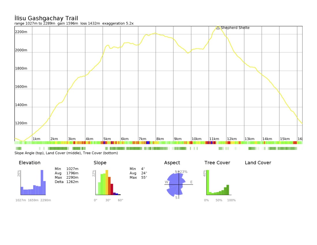
Gashgachay – Ilisu: 18 km, +1560m / – 1546m (E → W)
This section of the TCT is a challenging yet rewarding route through the remote highlands between Gashgachay and Ilisu. While the previous segment from Gumukh to Gashgachay is relatively short and may only take half a day, it is not advisable to begin this trail late in the day. The upcoming stretch has few reliable water sources and limited camping opportunities, making careful planning essential.
Trail description
Departing from Gashgachay, the trail ascends steadily on a narrow, rocky dirt path that carves through the dense forest. Around 2 km in, you’ll reach a small spring—one of the last reliable water sources before reaching higher elevations. Take advantage of this spot to refill before continuing your climb.
If you pass a wooden gate at the entrance to a more enclosed forest path, be sure to open it carefully and close it behind you. Shortly after, expect a short section of overgrown bushes and vines before emerging above the treeline. Here, the landscape shifts dramatically, revealing a vast alpine expanse dotted with a few shepherd shelters.
You will pass a shepherd shelter, after which the route veers right (northeast) and begins another ascent. Follow the remnants of an old dirt road as it transitions into a narrow footpath etched into the left side of the mountain.
From here, the trail remains mostly clear, though some sections may be slightly overgrown. As you crest the mountain, the path may disappear in the grass, and the entrance to the forest may be obscured by overgrowth. You will cross a grassy field with no markings to reach a rocky climb to the next ridgeline, atop which is another shepherd shelter. During the herding season, the area is guarded by dogs who will likely spot you from a distance.
Once past this last uphill push, the descent into Ilisu begins. The path transitions into a rocky downhill stretch before easing into a grassy trail, where multiple animal paths crisscross the terrain. The descent continues steeply for about 2 km, winding through sections of narrow forest trails before reaching the ruins of Galacha, also known as Shamil’s Fortress—a historic 19th-century stronghold.
To enter Ilisu, follow the wide path leading to the right of the fortress. Ilisu is one of the larger villages along the trail, offering markets, restaurants, and accommodation options.
Trail conditions
The trail is relatively strenuous, with significant elevation gain and limited water sources. Be sure to carry enough food and water.
Expect some sections to be overgrown, particularly near the treeline and in the forested descent.
The steep downhill into Ilisu can be challenging in wet conditions.
The trail between Gashgachay and Ilisu was previously marked by the Azerbaijan Tourism Board, but many signposts have since been removed. GPS navigation is essential.
Water
Occasional springs may be found near shepherd shelters, but they are not reliable.
Trail access
On the eastern end, Gashgachay village is accessible by unpaved roads.
On the west, Ilisu is a well-connected village with an asphalt road leading to major routes.
Trail amenities
There is a small market in Gashgachay, Should you choose to spend the night indoors in the village, there is a restaurant with a modest cottage offering, called Aydara.
- Ziyaddin: +994 51 848 43 67
Ilisu is a fairly populous village and a popular tourist destination, offering a range of markets, restaurants, guesthouses, and hotels.
Accommodation options:
- Gojayev Azer: +994 51 808 5274
- Mirzayeva Gulum: +994 50 484 9694
- Sangar Gala Hotel: +994 51 930 5505
- Hotel Pension Ilisu: +994 50 328 5615
Cultural heritage sites
The ruins of 19th-century Shamil’s Fortress (Galacha) above Ilisu are representative of the region’s past during the Caucasian Wars.
