#BlazetheTCT Day 11: Pona to Oni
Welcome to Day 11 of #BlazeTheTCT!
Today’s route takes us from the quiet valleys of Imereti in central Georgia north into the rugged beauty of Racha.

We’ll cross Georgia’s major new highway, meander through small villages, and climb high to a ridge for our first close-up views of the mighty Greater Caucasus. This is a section of big transitions—from lowlands to highlands, from gentle roads to steep climbs, and from the quiet bustle of Imeretian villages to the deep forests of Racha.
We’ve got 4 days left on our virtual thru-hike along the Transcaucasian Trail– so let’s hit the trail, see what surprises await us today, and don’t forget to donate today to help us blaze the TCT!
Happy trails,
Meagan

Village encounters in Imereti. Analog photo by hiker Tom Runge.
Walk through the quiet villages of Imereti
The day starts with a peaceful walk through the gentle valleys of Imereti. Imereti is the most populous region of Georgia– although you wouldn’t know it from this route, which sticks to villages and fields far from the population centers. But you’ll meet many curious people along the way: hikers aren’t a common sight around here.

You follow abandoned 4×4 tracks through fields and over forested passes. You hitch a short ride to avoid a section of the busy new highway. You walk quiet village roads alongside gentle rivers. You walk and walk and walk, getting used to the bemused looks of passing drivers. And occasionally, you duck uphill on small forest paths, gaining a bit of elevation along with the sense that you’re discovering some secret village paths.
This part of Imereti isn’t exactly on most hikers’ bucket list, but that’s part of what makes it so charming, with the right expectations. This section is less about hiking in the sporty sense, and more about a long, meandering walk through backroads and village life, getting a real window into life in Georgian villages.
It’s a place where we think the TCT’s strength as a cultural experience really shines. And it’s a lovely region to go for a walk.


Village life in Imereti. Photos by hiker Tanel Tilk.
If you’re lucky, you might also be invited in by a family on the way. Imereti is traditionally an agricultural region, well-known for its grapes– and more recently, excellent local wineries, which have led to the revival of several endemic Georgian grape varietals. It’s also the source of several famous Georgian dishes, perhaps most notably the imeruli khatchapuri, Georgia’s classic bread with cheese inside.
In the future, we’re aiming to improve large parts of this route, moving it off roads and more onto trails– and figuring out the big puzzle piece of circumventing the highway construction.
But in the meantime, enjoy your quiet walk through the villages, and don’t forget to take the time to stop and chat.

Friendly greetings– and lots of curiosity about a hiker’s drone– in Imereti. Drone photo by hiker Tanel Tilk.
Climbing from the lowlands to the high hills
After your long walk through the hills and valleys of Imereti, you start the climb into the next piece of the TCT: the new Imereti-Racha section, connecting the lowlands and the highlands.
The ascent is gradual at first as you follow a small trail out of the village of Drbo, crossing streams and passing shepherds’ huts, but soon enough, you’re gaining serious elevation as you leave the lowlands behind. The landscape begins to shift—the air grows cooler, the trees shorter, and the views through the gaps in the trees more expansive.

Climbing through the forest of Imereti.
This climb is no joke. You gain around 2,000 meters of elevation as you make your way up the ridge that divides Imereti and Racha. But all your sweat pays off. As you near the top ridge, you finally crest the treeline, and you’re able to look far over the valleys of Imereti that you’ve just traversed.

Happy hikers with Imereti in the background.
Just a bit farther, you think, and you’re relieved when the steep gradient of the trail finally begins to level out into a gently curving path hugging the sides of the ridge.
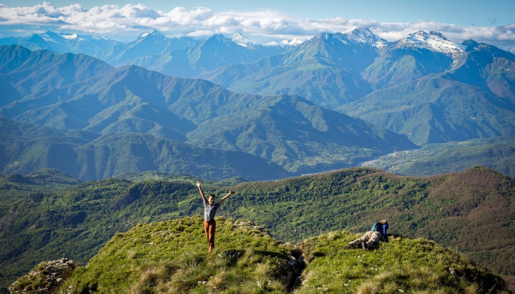
You trace the sidelines of the hills, looking back at Imereti– and suddenly you come to a small notch and the views open up to the north as you officially cross into the new region of Racha.
And there it is: the snow-capped wall of the Greater Caucasus. The peaks you’ve been inching towards, step by step, for over a thousand kilometers.
And, I mean: Wow.

Wow, right?
Walk the ridge to the King Tamar Cliffs
You continue along the ridge, feeling like you’re walking on the edge of the world, with the valleys of Racha spread out below you like a green patchwork quilt.
The old shepherding trail leads you to the dramatic King Tamar Cliffs, an imposing formation looming over the forests below. Named after Georgia’s legendary female King Tamar, who ruled during the country’s Golden Age in the 12th century, these cliffs are as awe-inspiring as the legends of the king herself.

The King Tamar Cliffs.
Try shkmeruli, the local specialty
Just below you as you traverse the ridge is the village of Shkmeri, where you might decide to make a short culinary pilgrimage: It’s the original home of the incredible Georgian dish shkmeruli, chicken in garlic, which you should definitely not eat without first consulting your tent partner (or do, and save it all for yourself, but don’t blame us for the consequences).
There are a number of legends about the origins of this dish, but they all revolve around this tiny village and a host with unexpected guests adding a huge amount of garlic to hide the age of the chicken. Regardless of its origins, it produced a masterpiece.

A Rachan feast, Shkmeruli center left.
Follow a piece of TCT history below the cliffs down to Korta
After taking a long break to snack up and admire the views from the cliffs, you begin the steep descent.
You follow the TCT though a small notch in the cliffs, where a historical trail winds gently down to the forest.

The King Tamar Cliffs from below.
This trail is a bit of TCT history– a gem of the region that we’re proud to have re-discovered and re-opened.
TCT Georgia technical manager Giorgi Jmukhadze is from the region of Racha and spent many summers of his childhood in the area between the cliffs at Skhmeri and Oni to the north. So when Gio began working on expanding the TCT in Racha, it became a personal as well as professional project for him to find a trail connecting the lower forest with the spectacular cliffs above.

TCT Georgia Technical Manager Giorgi Jmukhadze on the trail connecting Imereti & Racha.
In 2021, Gio and the TCT Georgia team undertook a big scouting project to identify potential routes between the cliffs and lower valleys– eventually finding a big win in the village of Korta.
We had some help from Korta local Bondo Goglidze, who confirmed that there was indeed an old route and pointed us in the right direction.

Bondo and members of the TCT team after a successful scouting mission in Korta.
The first attempt we made to reach the cliffs involved climbing straight up a steep couloir with no trail– not ideal for sending hikers on. But the historical trail that Gio found is a thing of beauty.
And it keeps on getting better, bit by bit: Each year since 2022, we’ve sent trail crews out to improve this trail. They’ve cleared back huge amounts of overgrowth and stabilized parts of the tread. And this year they’re out blazing this section so that future hikers can find their way more easily.

Our 2024 Caucasus Conservation Corps crew of Georgian & Armenian crew members on a multi-day blazing hitch along this section.
So as you descend below the cliffs, you follow freshly-painted red-and-white blazes all the way down into the forest. Navigation can be tricky on this old trail– thank goodness for those blazes, right? 🙂
The trail eventually leads you to the village of Korta, the last settlement at the base of the mountain. Is there much happening in Korta? Well, no, but it’s a friendly place.
And from here, it’s an easy road walk— or, just as likely, a hitchhike with a laughing local who offers you a ride— into the town of Oni.


Hospitality in Korta.
Rest your feet in Oni
Oni is your final destination for the day, a charming town nestled in the Rioni River valley. Oni has a rich history of being an important trade center in the region, dating back to the 15th century. Today, it’s known for its beautiful stone architecture, its vibrant Jewish heritage, and serving as a gateway to the stunning mountains around.
You’ll likely find yourself at Family Gallery Guesthouse, a favorite among hikers. The cozy atmosphere, delicious home-cooked meals, and warm hospitality make it the perfect place to rest your weary legs– but so do its famous hosts, with their staggering wealth of knowledge about the region.
Oni might be small, but it’s full of character, so take your time and enjoy– it’s your last civilization for a while.

The Oni Synagogue. Photo: Georgian Holidays.
Tomorrow we’re heading deep into the mountains– yes, those mountains– and tackling the TCT’s toughest bushwhack before we pay a visit to the trail crews working hard to build a new trail connecting to the neighboring region.
So rest those feet, and we’ll see you tomorrow back on the TCT!
And that’s 1100km down on the TCT!
Stay tuned, and we’ll see you on the TCT tomorrow as we head deep into the Greater Caucasus, bushwhacking our way through the old trail connecting Racha and Svaneti, and meet the crews working to re-open this historic section.
We hope you’re enjoying coming with us on the trail and meeting some of the people and places behind it. Over our 15 days of hiking the TCT, we’re aiming to raise $30,000 to blaze new sections of the trail and to continue our work to make these spectacular areas accessible. And the countdown is on now– we’ve got 4 more days!
If you’ve enjoyed the trail in the past or are dreaming of hiking it someday, please join us to make these efforts possible. Donate $15 or more and share with 15 friends today to blaze the TCT.
Thanks for all your support, and happy trails – we’ll see you back on the TCT tomorrow!
Meagan & the TCT team


