
Day Hikes from Mazeri
Mazeri is the traditional starting point from which mountaineers embark upon their ascent of Mt. Ushba, one of the most difficult Caucasus peaks to summit. For those wanting to get a closer look at the mountain without endeavoring to climb it, a popular hiking trail leading to Shdugra Waterfall and Ushba Glacier begins from Mazeri and heads north along the plains before ascending into the mountains. For those wanting a relatively easy hike with spectacular views, Shdugra Waterfall is an excellent destination. Hikers wanting more of a challenge can continue on to Ushba Glacier. Although the trail to the glacier from the waterfall is only a couple of kilometers long, the elevation gain and steepness of the trail can be challenging.
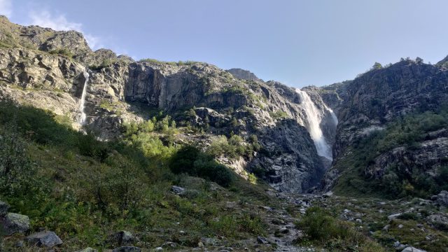
Shdugra Waterfall
OVERVIEW
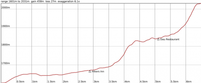
Distance: 6.5 km
Approximate Time: 2.5 hours
Elevation Gain/Loss: 458 m / 28 m
Difficulty Level: Easy
Max/Min Altitude: 2032 m / 1601 m
Elevation Profile
Route Description
From the Tvbishi Mineral Spring, continue north on the road (don’t cross the bridge over the Dolra River!). At the trail split, walk through the fence and through the lumber yard. Turn left and meet the path leading you north. Continue along the trail through the meadows, keeping the Dolra River on your right, and you will come to the small Narzan Mineral Spring on your right and a church soon afterwards. The trail continues north from the church, over a small spring and another larger stream covered in stones.
After about 3.5 km from the start, you will see a bridge over the Dolra and come to Hikers Inn. The trail leads right through the inn, and continues along the river, slowly climbing up. After 2.2 km, you will come across Dau, a restaurant and rest area with food, beverages, tables, and hammocks. From here, continue along the forest trail until you come to a wooden bridge crossing the Dolra. Cross the bridge, and soon you will pass through the border patrol. They may ask for your passport, but more likely they will just greet you with a wave and “Gamarjoba.”
From here, the path remains clear and ascends more steeply. At the turnoff for the Shdugra Waterfall viewpoint, you will see a yellow sign and a red and white painted arrow pointing the way to the right. Follow the trail over a small stream until you come close to the river with a view of the falls. Return on the same route.
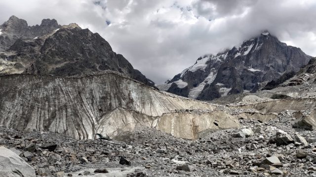
Ushba Glacier
Overview
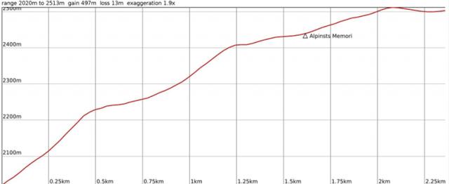
Distance: 2.36 km
Approximate Time: 2 hours
Elevation Gain/Loss: 494 m / 13 m
Difficulty Level: Difficult
Max/Min Altitude: 2513 m / 2220 m
Elevation Profile (from Shdugra Waterfall)
Route Description
The trail from the waterfall is short, but incredibly steep. At the turnoff for the Shdugra Waterfall viewpoint, continue straight along the trail. At the split, turn left and continue ascending. You will come to a stream with a path leading up along the stream and a path across the stream. Cross the stream and continue on that trail, which ascends steeply. About 470 m from the start of this trail, it turns sharply to the right. The turn is marked with a cairn, but is nearly impossible to see because it blends in with the landscape. If you begin climbing rocks, you have missed the turn.
The trail immediately passes through a narrow rocky ledge, and then levels off to a forested trail. After approximately 500 m, you will cross the river leading to Shdugra Waterfall. It is powerful, but crossable with caution. Numerous cairns mark possible crossing points. After the river, the trail ascends through the forest. At the edge of the forest, the trail opens up to a moraine. From here, go straight. The trail is marked with blazes, but it is also clear in which direction you need to go. The trail will soon lead you to a memorial for the alpinists who perished on Ushba.
The trail splits at the memorial. Take the left fork. From here, the path is marked with cairns, but you can also make your way towards the glacier on your own. Take caution as you traverse the rocks, and stay clear of the glacier itself. Return on the same route.
