#BlazetheTCT Day 5: Hors to Sevan
Welcome back to Day 5 of #BlazeTheTCT!
Today, we leave the desert far behind and embark on one of the most remote and challenging sections of the Transcaucasian Trail: traversing the rugged highlands of the Gegham Mountains.
There’s no towns up here, no village markets or shelters– only the wide-open landscape, the big booming sky, and the occasional semi-nomadic herder camps that you’ll pass. You’re on your own.
Pack up your gear and get ready to ascend into the clouds—we’re heading from Hors to Sevan, and it’s going to be a trek you won’t soon forget.
Happy trails,
Meagan

Day 5: Hors to Sevan
Cross the Argichi Floodplain
In the early morning light, you leave behind the sleepy town of Hors– and the nearby bears (link to day 4)— and make your way towards the expansive floodplain of the Argichi River.
You follow a grassy 4×4 track through fields of poppies, using the breathtaking views that stretch south into Vayots Dzor to keep your mind off the mosquitos.

As you climb, you celebrate crossing into another new province: Vayots Dzor into Gegharkunik. Congratulations!
Without warning, the landscape abruptly transitions from rugged valleys to the fertile, grassy plateau of the Argichi floodplain, lying at an elevation of 2,200–2,300 meters.

The rivers here– the Gayladzor, Argichi, and Nazarkhane– flow lazily through the wetlands. They create a network of meandering streams that you’ll need to cross carefully, mindful of the spring thaw and recent rains that can swell these waters unexpectedly.
There’s no way to avoid wet feet here. Instead you decide to enjoy the mid-hike ice bath on your sore feet.
You gingerly make your way across following the wide fords used by Soviet trucks, laughing at the shock of cold water.

Say hello to the haymakers of Gegharkunik
As you traverse these grassy flatlands, the sounds of hay cutters greet your ears—scythes slicing through the long grass, accompanied by the rhythmic rumbling of old Soviet trucks.

During the height of summer, these fields become a hive of activity as locals from nearby villages set up temporary camps for haymaking season.
You exchange friendly waves with the workers, who beckon you over for a cup of Armenian coffee.
The scent of freshly cut hay lingers in the air as you continue on, the summer sun casting long shadows over the meadows.


Friendly greetings from the hay makers in the Argichi floodplain.
Camp at a Mineral Spring Oasis
As the afternoon heat fades into the soft colors of evening, you follow a side trail into a small valley with a hidden gem—a natural mineral spring piped straight from the ground.
Anyone who’s spent time in the Caucasus knows that the region takes its mineral water seriously, and this stuff is the cream of the crop: perfectly cold sparkling, with just a hint of minerality and none of the sulfuric egginess.
Right beside the mineral spring, you find a stone picnic table and space for a couple of tents– the perfect place to spend the night.
You take a break here, filling your water bottles with the crisp, cold spring water and soaking in the quiet of the valley, only interrupted by a few shepherds and their flocks making their way home in the evening.


Look over the edge of Khosrov Forest
Refreshed and ready to tackle the next leg of the journey, you follow the line on the map through open fields and ridgelines as it skirts the boundary of Khosrov Forest State Reserve.
Up here, the landscape is wide open and battered by wind, revealing the impressive Khachadzor (‘Cross Canyon’) gorge. In the distance, just across the border, the snow-capped peak of Mt. Ararat dominates the horizon.
The path hugs the ridgeline, offering panoramic views that seem to stretch on forever—a mosaic of the green valleys and gently sloping volcanic peaks that define the Gegham Mountains.

Puzzle at the Abandoned Soviet Base
As you climb the ridgeline higher, the abandoned ruins of an improbably isolated series of buildings come into view.
A local once told us these ruined structures were a strategic installation of some kind in Soviet times. On a clear day it’s possible to see hundreds of km beyond the Iron Curtain and into Turkey, so it kind of makes sense, but… who knows.
Either way, its crumbling structures stand as a stark reminder of the region’s turbulent past and the human history of these mountains, even all the way up here.

Below, a dirt road cuts through the valley, marking the divide between the Ararat plains to the west and the Sevan basin to the east.
You cross this road and begin the climb northward, following livestock trails that snake up the narrow side valley.
Traverse Pokr Spitakasar– the Little White Mountain
As the day progresses, you find yourself on the flanks of Pokr Spitakasar (‘Little White Mountain’), standing at an imposing 3,485 meters.
The trail here is a mix of terrain and narrow paths used by herders, skirting the western and northern slopes of the mountain.
You carefully navigate the lingering snowfields, the remnants of winter clinging stubbornly to the north-facing slopes.


The peak of Pokr Spitakasar is a non-technical climb, and the summit offers an unparalleled vantage point.
From here, you can see several nomad camps dotted across the landscape, the canvas tents blending seamlessly with the sloping terrain. The descent is straightforward, leading you down to the expansive grassy steppe that characterizes this central, highest, and most remote part of the range.

Say hello to the nomadic herders
As you descend, you encounter the semi-nomadic Yezidi herders, their flocks grazing on the lush pastures. These herders, who migrate to these highlands every summer, are a vital part of the region’s cultural tapestry.

The guard dogs, however, are less welcoming—fierce protectors of the herds and camps. They’re by far the biggest animal threat along the TCT, and you can’t help your heart from pounding wildly as they bark in the distance.

You try to give the camps a wide berth, knowing the dogs are doing their job, and instead exchange friendly waves and greetings with the herders from a safe distance.
If you’re lucky, a Yezidi family invites you for a cup of strong coffee and a sweet treat—a gesture of hospitality that is always offered with warmth, despite their limited supplies.


Hospitality at the herders’ camps
Survive a thunderstorm at Badi Lich
As the sun begins to set, you reach the southern rim of Badi Lich (‘Duck Lake’), a dramatic crater lake that offers a perfect campsite.
The lakeside is relatively sheltered, and the still waters reflect the surrounding peaks, creating a serene and almost otherworldly atmosphere. To the west, the red-coloured volcano of Mt. Nazeli (3,312m) looms, its striking appearance typical of the central Geghama mountains.


As night falls, you settle in for what promises to be a peaceful evening—until the first rumble of thunder echoes through the mountains, heralding the arrival of one of the Geghams’ infamous thunderstorms.
The skies open up, and you find yourself huddled in your tent, bracing against the wind and the stinging hail that rattles against the fabric.
It’s a night of raw, elemental power– and only a little bit of whimpering in your tent– as the thunder echoes through the valleys.
But for better or for worse, surviving a Gegham thunderstorm has become something of a rite of passage along the TCT. So congratulations. You’ve passed.


The aftermath of a storm in the Gegham Mountains. Yes, that’s hail.
Climb Azhdahak to see the crater lake
Morning comes, and with it, a clear, crisp sky. Today, you tackle the highest point on the Armenian TCT: Mt. Azhdahak, standing tall at 3,579 meters.

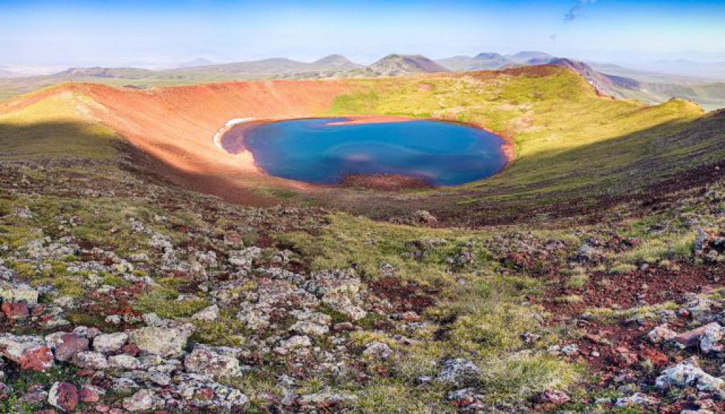
The climb begins with a non-technical scramble up the boulder-strewn hillside, following the gentle gradient across the lava flow. As you near the summit, the crater lake comes into view, its water a striking contrast against the red rock surrounding it.
The final ascent is steep but rewarding, and from the summit, you’re treated to an expansive panoramic view that takes in the entire Geghama range. The crater rim itself makes for a perfect loop hike if time allows, and if you’re feeling brave, a quick dip in the icy waters of the crater lake might just be the perfect way to celebrate your accomplishment.

Rest at Highland Camp
Descending from Azhdahak, you find respite at the new Highland Camp, established by local entrepreneur and mountaineer Tigran. This impressive operation offers bunk beds, a kitchen, and even wifi—quite a lot of luxury in these remote parts.
You stop in for a hot cup of tea, sharing stories with other hikers and soaking in the breathtaking views of the surrounding peaks.
And as the afternoon dips into evening, perhaps you might decide to spend the night here, enjoying the warmth of a bed and the incredible stargazing of this remote plateau.


Highland Camp at the base of Azhdahak.
Trace the shore of Akna Lich
The trail continues around the shallow crater lake of Akna Lich (“Eye Lake”), the largest body of water in the Geghama range. The route detours around several nomad camps, reducing the risk of encountering aggressive dogs, and brings you to the lake’s northern shore.
The calm waters of Akna reflect the blue sky above, creating a peaceful atmosphere that belies the ruggedness of the terrain. Here, you’re likely to meet other hikers and campers, who drive up from Yerevan to escape the city heat.

The road to Akna Lich.
Descend to Sevan
From Akna Lich, the trail gradually descends, weaving between the domed peaks of Karaganchal, Shishdebe, Kermesdepe, Mazaz, and others.
Like many of the mountains in the range, these peaks bear both an Armenian name and an alternative Kurdish name reflecting the presence of the Yezidi tribe in the region. Most nomad camps remain populated by ethnic Yezidis who speak a Kurdish dialect and still use their own traditional names, even if the peaks have different ‘official’ names. (Often the Armenian and Yezidi names will be direct translations of each other, but this is not always the case.)
The landscape begins to soften as you descend below 2,000 meters, the land becoming more cultivated as you approach civilization once more.

Your final destination is the small city of Sevan. Here, you stop for fresh lavash and produce before continuing on to Sevanavank Peninsula.

The day ends with a visit to the popular Sevanavank Monastery, perched on a hill overlooking the blue waters of Lake Sevan. Its ancient stone walls and stunning views make for a fitting conclusion to this challenging section of the TCT– even if it’s a big shock to the system to suddenly see so many people.

Sevanavank. (Wikimedia Commons / Vigen Hakhverdyan)
As the sun sets, you check into the unique Soviet Writers’ House, an architectural landmark that now allows travelers to stay. You sit on the balcony overlooking the lake, put your feet up, and start scribbling your notes from the trail.


Congratulations—you’ve just completed one of the most difficult and rewarding sections of the Transcaucasian Trail!
We hope you’re enjoying coming with us on the trail and meeting some of the people and places behind it. Over our 15 days of hiking the TCT, we’re aiming to raise $30,000 to blaze new sections of the trail and to continue our work to make these spectacular areas accessible.
Parts of this section have been maintained and blazed, but other parts need work.
If you’ve enjoyed the trail in the past or are dreaming of hiking it someday, please join us to make these efforts possible. Donate $15 or more and share with 15 friends today to blaze the TCT.
Thanks for all your support, and happy trails – we’ll see you back on the TCT tomorrow!
Meagan & the TCT team


