Hike Vayots Dzor: New Trails, Ancient Trails, and Navigating Off-Trail with Armenia’s Newest Topo Map
This is a guest post by Alessandro Mambelli, Director & Co-Founder of our longtime partner Cartisan. Cartisan has been working to create the Caucasus’ first high-quality topographic hiking maps since 2018, and they just released their new map of the Vayots Dzor region— which we just took out on the trails for the first time.
Ale claims that he’s too old for the live updates of the trek we were doing last week (highlighted on our Instagram if you missed it). We’re not sure about that, but he’s been compiling a highly entertaining account of their journey over on the Cartisan blog, so we’re sharing a (lightly edited & condensed) version here.
Enjoy and we hope you’ll come join us in Vayots Dzor at some point!

Day 1
First of all, why was this area of Vayots Dzor chosen for our second map?
This area was initially identified by the Transcaucasian Expedition back in 2016, for a somewhat unusual reason: it seemed like nobody would ever go hiking in this particular area of the central Armenia province of Vayots Dzor.
Intrigued by that, Tom Allen, leader of said expedition, decided we should go and check it out, to see if there was a possible worthy route to connect to southern Armenia through those volcanic valleys.
We ended up spending many weeks up there trying to find old trails, “unintentionally” climbing over massive rocky cliffs, and generally wandering around a landscape that didn’t seem to get any attention, for all the wrong reasons. Luckily things were about to change.
When the TCT was finally set to route the trail through these mountains, HIKEArmenia made the wise decision of supporting and leading the creation of a whole new trail network around the long distance route, so that people could stay more days in the region. Fast forward to 2019, several new and old trails were now connecting the villages of Gomk, Martiros, and Artavan. This meant that after Dilijan National Park, in the north, this was to be the second hiking hub with a decent amount of hiking trails for you to explore in Armenia.

Having been there at the very beginning of the process, many thoughts were rushing through my mind while walking on those paths, four years after my first journey. The truth is, it is quite indescribable what it felt and meant to be there now, seeing how it all came together.
A lot of manual labour was necessary for Cartisan to bring the map data up to scratch, and a lot of sweat has been poured by Trails For Change to actually build or renovate trails on the ground, so finally having the chance to walk across this landscape again, ages after our early explorations, was kind of surreal and so very satisfying.
Despite the heat and heavy packs, the first day was really fun, and a long awaited one as well. All on a brand new trail connecting Gomk to the Rock-Hewn Martirosants church above Martiros. It was the hottest day of the year (so far?) but it wasn’t so bad because we were hiking around 2000m, in a gentle breeze, with plenty of water, and this company.

Day 2
We had an early start on day 2, as we headed up an ancient trail climbing above Rock-Hewn Martirosants towards the Martiros Waterfall. It was a wide trail, enough to possibly be a caravan route. Climbing up this side valley in Vayots Dzor, looking beyond the faraway mountain passes on the horizon, we couldn’t help imagine where this route could have once taken us, further south along …the Silk Road? One of the Silk Roads? I guess it was the terrain that was, somehow, speaking to us.
The trail itself was beautiful, and it’s now been renovated to be passable once again, but the most striking thing was that we could feel the history and the significance of the route— if for no other reason than because the sheer amount of work evidently required to carve its way up this rocky valley was itself a statement of its importance.
I couldn’t help but imagine us among a caravan of mules climbing their way to exotic markets, colorful merchants venturing out looking for fortunes and the comfort of the next caravanserai, loaded with all sorts of paraphernalia. It was a fun scene.

Upon reaching Martiros waterfall, after the obligatory refreshing plunge in a pond just above it, a little deeper upstream in the Gomeri gorge, we didn’t have a marked trail to follow, so we agreed to launch into unmarked territory. We discussed with Tsovinar, as she was nominated map navigator for the day, and as we finally spotted the trail continuing up on the other side of the river, we went off-piste.
There was a hint of that trail on the map, passing along some ruins, but it abruptly ended in a place where the terrain seemed to flatten up. There was also a jeep track mapped around 40 meters above that point, so we thought we would be able to find it– if it existed. As soon as we reached the ruins, we noticed there were actually more ruins hiding in the overgrown grassland that we hadn’t been able to see before on satellite imagery.

One thing now was sure, that trail on the map would require more definition, and I wondered why nobody had decided to come this way before… It was certainly good for our sense of discovering, but better data would give us an easier path to follow. Just maybe less fun than what we instead had while guessing our way up until we found it.
At the top, that trail did end abruptly as told by the map, vanishing into an open field. I guess no more work felt required by those ancient route builders, as walking across open flat lands is easier than carving a trail? And again, we did find that jeep track above. It was exactly where you would expect it to be– at the foot of the next hill, crossing a ravine at the point where it was shallower.
This had become the theme of the day: with no marked trails, but a topographic map in hand, you end up looking for your surroundings more attentively; you kind of start to think as a trail builder, or an animal for that matter, looking for the more natural routes, smooth passages through the landscape to get you to or through natural points of interest around you (water, opening in vertical cliffs, fords, etc.).
This landscape reading started to become really fun. To an expert natural navigator, it must look all quite obvious: things are where they are for good reason, so if you look in the right place, you end up finding them. It wasn’t always obvious to me, but once you start getting it, even just a little, it feels so empowering!
That was my main takeaway for that day: there is a trade-off between the immediateness of a GPS reading and the connection with the landscape that a paper topographic map will encourage. It’s not a matter of which one is better, but rather, a choice we can consciously make. Do I want to better understand my place in this scenery I am currently immersed in, or am I pressed for time and just want to locate myself?
Both methods can fail, but if fun and satisfaction is what you are after, learning to read a paper map in relationship with the space around is certainly a good idea, and I’m thankful that this trip has reminded me of that.

Day 3
On day 3 we left the village of Kapuyt aiming for Artavan, the main village on the next valley to the north. To reach the blazed trails that would get us across the mountains, we chose an alternative way to exit Kapuyt: on the map there was a path circling around the farms at the edge of the village, which seemed nicer and was also passing through some interesting khachkars (cross-stone) carved into a cliff, so we asked Tsovinar to take us that way.
As we headed further up the mountains I thought this path must have been similar to the one Ashot, a local farmer I met here 4 years ago, had shown me to get up towards that same pass we were going for today. But I couldn’t quite recognise it until we reached further up and, looking down over a ridge, I finally saw what must have been the way Ashot took me last time.
The one we were walking on now was a much nicer option, and that sparked the first interesting realisation of the day: if you ask a local for a path to go somewhere, they’ll show you the most straightforward connection. And it makes sense, these people work in the mountains, they need to be efficient above anything else.
Unfortunately this doesn’t always match well with the work of trail designers, who are instead looking for gentler gradients and better views to give hikers a good experience. It was interesting to notice how the practicalities of the different uses of mountain paths could affect the way you look for routes across the same landscape.

On top of the pass, we begun following a very nice brand new trail built by HIKEArmenia and Trails For Change, constellated with what seemed like nature-built Japanese rock gardens, with interesting combinations of succulent plants, thorny bushes, and clusters of colourful wildflowers.
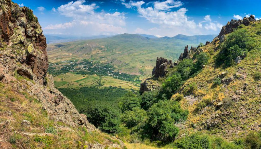
At the end of that, we enter the magnificent Artavan oak forest, which looks like it’s hanging on the steep mountain side, where giant rock cliffs pierce through the canopy towards the sky in a very original juxtaposition of rock and trees.
On the way out from the forest, we ended up losing the trail. But I can’t say we got lost, really. We knew we were not where we were supposed to be, but we could tell still where we needed to go.
We were able to read the topography and that helped us figure out where we must have been instead, and that eventually led us through an alternative way towards the same destination. The perks of having a topo map with you, I guess. And it made it all more interesting, with a tinge of excitement, obviously.

Why did we lose the trail? Well, maybe we missed a turn, maybe we just couldn’t see the blazes, maybe there was a little too much overgrowth… it doesn’t matter much, though. What was important is that we still found our way to Artavan, and we learned a thing or two in the process:
Many organisations play an important part of this growing hiking industry in Armenia, which is young, so it naturally suffers from growing pains. But it is growing! And each organisation and individuals are contributing their specialised profession to the cause; now more than ever it is evident to me how interconnected each of these parts are.
Imperfection– enjoyable imperfection– was the theme of the day: the trail network could be certainly improved (better blazing, sometimes even better routes, some needed cleaning up due to little traffic) and I think it probably will, later on this year. The same can be said for our map, as we couldn’t possibly ground proof every square meter of the land we covered. We noticed missing objects that would definitely help navigating by eye and compass (like the presence of giant boulders or isolated trees), but we couldn’t see those features on the satellite imagery we use to improve the base maps.
In the end, it is worth reminding ourselves that we are opening up a new industry in Armenia, from scratch, and what matters to me is that we keep doing it all together.
Because there are several pieces to this puzzle, and I don’t think we can do without any of them: we need good quality trails, both in terms of design and construction; we need good blazing and functional signposts; we also need good maps, paper and digital ones; and we need at least some decent services offered along the paths, to cater to the needs of different types of hikers. If we needed a reminder of the importance of cooperating and coordinating our work, we got it on days like this.
In the meantime, given that nothing is perfect, and probably nothing ever will be, the best chance one has to maximise safety and enjoyment is redundancy: you can’t rely on one single piece of infrastructure, nor technology, nor equipment, nor even knowledge. Everything is prone to fail you at some point. So it’s more about understanding the options one has, their limitations, and equip oneself with as many tools one can use.
So, the trails are not perfect, nor is the map, nor are the apps. But they are already quite good, and as long as we keep working together to literally break new ground, I believe the hiking experience in Armenia will only keep improving, for everyone.

Day 4
For the first time in our trip we didn’t have to dismantle camp on the morning of day four. At the end of the day we were to come back to this beautiful campground in Artavan, with a view on the forested side of the mountain, which also meant that our packs were going to be lighter, and our tents would have a chance to dry up in the morning sun after the electric storms of the night before.
With the day all for ourselves we decided to go out and play. We only had a destination in mind, a turnaround point, and nothing more planned. It was a great plan.
We chose to walk up the valley towards the Andranik fortress, deliberately staying away from the blazed trails, just to test our navigation skills, and to see if we could enjoy a different path towards the fortress high up above the Hayeli lake.

We ended up crossing over a large abandoned settlement called Mayradurk, or Maratuz, full of ruins, khachkars, and even a little shrine with allegedly holy water that we would check out on the way back. We followed a ridge in between both marked trails, which were circling around us more widely in the side valleys, as we finally approached the lake with a famous “world map” in it.
This way gave us a chance to step through what must have been the old village’s paths, maybe even staircases, walking along walled paths that were taking us through the scattered ruins of what one day must have been a village full of life.
We had plenty of time to practice taking our bearings, trying to locate ourselves by looking at the topography and confirming the position with the compass reading, and in general brushing up half-forgotten skills at a leisurely pace. Because it’s not just about getting to the destination and back, but also about having fun in the mountains, isn’t it?
The views from Andranik Fortress were otherworldly. Beside the best look at the world map within the Hayeli lake – …can you see it?! Can you believe it!? – on the opposite direction we could also literally see the doors into the province of Syunik, the unfortunately infamous Amulsar mountain, and even a hint of Jermuk’s valley.

© Roffi Petrossian
We stopped for lunch up there, taking in the beautiful landscape from that stunning vantage point; I really urge you to check it out; just watch out for these guys on your way there… Using walking sticks to notify snakes of your presence is highly recommended across Vayots Dzor!

Day 5
Let’s keep it simple: it was long, it was tough, and it was awesome.
The views on the “Stairway to Heaven” trail, connecting Artavan to Kapuyt, were unbelievable. All I want to say about it is this: get ready for your feet to hurt, and for your heart to be full. Just go do it. And don’t forget to take a look around every once in a while, as you negotiate the ancient steps carved into mountain stone itself, climbing this “impossible” staircase. A friendly note: you won’t believe there is a way through the mountain as you approach it, but it’s there, just follow the blazes!
Finally, the last day on the trail, for me, was really all about the importance of maintaining and improving the cooperation among the hiking organisations. I say this based on our experience on the “Mountain Goat Trail” in the morning of our last day, which turned out to be a little… problematic. (Hint: unless you love bushwhacking on steep mountain-side forests, I’d avoid this particular trail for the time being.)

Anyway, as I mentioned already many times before, infrastructure building is a team sport. There are plenty of opportunities to develop trails and hiking hot spots everywhere, and I feel that to do it right we should work together, as we have done before, pulling together our strengths into a coordinated effort. From our contribution, we are more than happy to take the suggestion to organise mapping events for this happy gang of trail builders.
So let’s get some pizzas rolling sometime soon, and do some mapping together, shall we? It’s not as cool as going out hiking, or carving trails, but …who said we couldn’t just do all of them anyway?
Thanks again everyone for following along this greater adventure that is co-creating a hiking network in Armenia!


