How Drone Mapping Technology Is Helping Us Build Armenia’s First Long-Distance Hiking Trail
Since the early days of the Transcaucasian Trail we’ve experimented with drone mapping to further our trail-building ambitions and make our work more effective. The technology has progressed at an incredible pace since then, and now we’re very happy to announce DroneDeploy as our team in Armenia’s newest sponsor!
DroneDeploy’s world-leading drone software is typically used in commercial industries to plan, monitor and report on projects – but their nonprofit programme, Drones For Good, supports a broad spectrum of humanitarian and development work around the world, from disaster relief in Indonesia to ecosystem mapping in California… and now trail development in the mountains of the Caucasus.
To help explain how this technology is helping the Transcaucasian Trail come to life, here’s an example from our ongoing work in the Syunik province of southern Armenia to identify, map, and gradually restore the region’s extensive network of ancient trails.
(We don’t normally publish our internal field data like this, but in this case we reckon it makes for an interesting and insightful story…)

Before we head out to build a new trail or renovate an old one, we have to be sure that we’ve explored all possible options for the route in that area – that we’ve left no stone unturned when it comes to finding historic trails that might have passed beyond living memory.
This typically starts with desk research using freely available satellite imagery and historical maps, followed by a lot of on-the-ground explorations and surveying – and how long that takes depends on how complex the terrain and how rich the region in cultural heritage.
Sometimes it takes years of revisiting the same ground to pin down what we think is the optimal route for the trail through a given area – as was the case with the Vorotan Canyon around Tatev Monastery, an area we’ve returned to every year since 2016 in search of the perfect route.

There have always been inefficiencies in the trail scouting process. The free aerial imagery found online is usually good enough to recognise a road or jeep track, but it won’t reveal the narrow, overgrown paths that might have been out of use for decades. And while the historical maps sometimes show the more significant of these ancient trails, they tend be rough approximations, not accurate enough for navigation.
So we usually have to resort to guesswork, imagining logical routes between historic sites in combination with an understanding of how the trails of the past were designed and built, then starting our explorations facing a big stack of unknowns.
This is where the DroneDeploy platform becomes extremely useful.

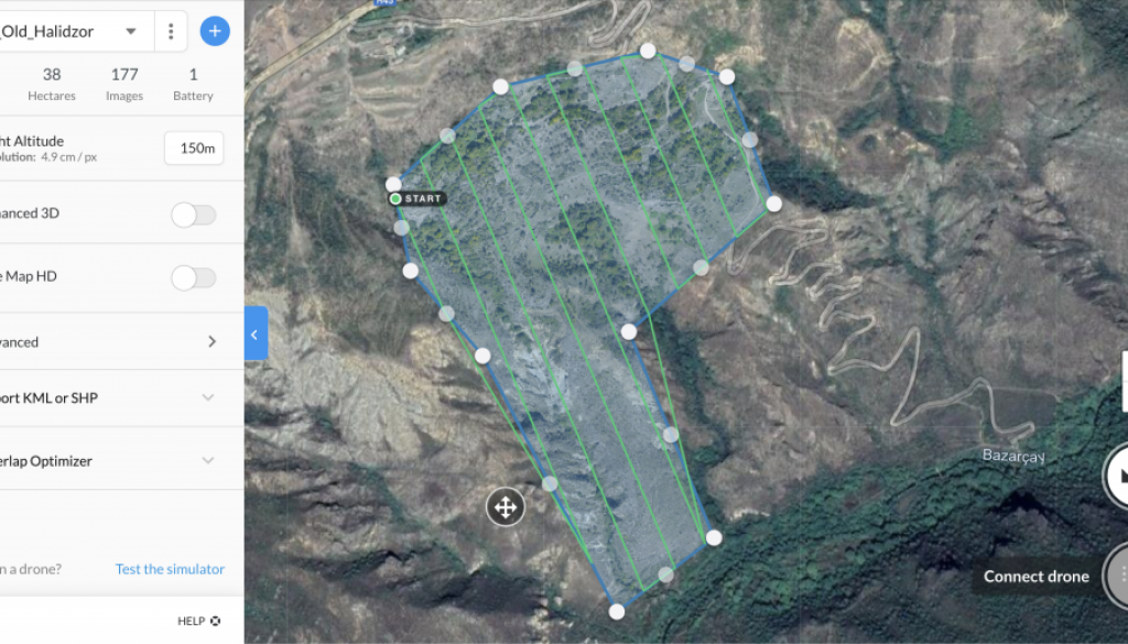
Take, for example, the ruined village of Old Halidzor, the extensive remains of which are spread across the steep slopes of the gorge. This is a key site of historical interest in the Vorotan Canyon.
At some point in modern history, a driveable 4×4 track was built to access the village while it was still inhabited. Modern maps of Armenia show this switchback road as the only way to connect the village with the main road above and the river below. Most hikers therefore use this route to ascend and descend the gorge.

But hiking on jeep tracks isn’t our idea of fun – and it certainly doesn’t fit the Transcaucasian Trail vision of a ‘world-class’ trail!
On closer inspection, it turns out a Soviet military map from 1955 shows another route to the west, drawn using the symbolism for a footpath or cart track in this particular cartographic style.

But the free aerial imagery is just too blurry to provide confirmation of whether this trail exists, and precisely what route it takes. Not just that, but the 3D models used by apps like Google Earth smooth out the terrain to a point where it is no longer useful. Simply heading out and exploring this potential trail on foot would be possible, of course, but it would be slow, and we’d have little assurance that it was the best use of our time.
Here’s the clever part.
A single 15-minute drone flight, launched from the roadside above, is enough to cover the whole of Old Halidzor village and the entire corridor of the unexplored trail below, all the way down to the river – where the historic map also shows a bridge once existed.

This brand new aerial imagery gives us a vastly clearer picture; easily enough to make out what is and isn’t a viable route – the crucial difference between an efficient trail scouting mission and many hours of bushwhacking through thorn bushes and following dead-end cow paths along steep, rocky mountainsides.


Even cleverer, our trail scouting teams get direct access to this imagery on their smartphones. So if they do lose the trail while conducting the GPS survey, they can refer to detailed, high-res aerial imagery to get back on track.

This doesn’t require us – a small regional NGO with a tight operating budget – to invest tens of thousands of dollars in specialised gear. The drone we use is a consumer-level DJI Mavic Pro kit, bought off-the-shelf for a little over $1,000. And the software runs on any modern Android or iOS smartphone, which we all have in our pockets.
Together with our Land Rover Georgina’s off-road prowess and her equipment-charging capabilities, DroneDeploy’s powerful platform gives us a mobile drone-mapping platform that can knock off several flights a day in all manner of terrain and deliver the data straight to the scouting team for follow-up.

This is one of two main ways we’re harnessing the power of drone technology in partnership with DroneDeploy to get the Transcaucasian Trail built! In the next post we’ll how our cartographic team are using drone imagery to produce topographic hiking maps at an unprecedented level of detail.


