#BlazetheTCT Day 8: Tsater to Lake Arpi
Welcome to Day 8 of #BlazeTheTCT!
Today marks a milestone—our last day hiking the TCT through Armenia and halfway through our 15-day campaign to Blaze the Transcaucasian Trail!
Today we’re hiking from Lori into Shirak, our final province in Armenia, all the way from the depths of the Dzoraget Canyon to the high plateaus of Lake Arpi National Park at the northern border with Georgia.

Along the way we’ll visit a 7th-century monastery, climb a rock-hewn staircase out of the canyon, toast with highland farmers, pick wild strawberries, stop at an ancient megalithic highway, and try to spot a Dalmatian pelican in Lake Arpi National Park. It’s the final stretch of our 800-kilometer journey across Armenia before we cross into Georgia.
So, lace up your boots on-e last time for Armenia—let’s show our support for the trail and make this section one to remember!
Happy trails,
Meagan

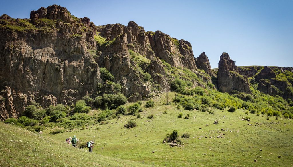
Hiking out of yesterday’s rest stop of Tsater. Get a load of those beautiful fresh blazes– more of those to come!
Day 8: Tsater to Lake Arpi
Traverse the Dzoraget Canyon
Your day kicks off with a descent into the dramatic canyon of the river Dzoraget.
You follow the TCT along a mix of historical paths and dirt roads, winding through steep cliffs and dense greenery.

The sun is intense out here, but the movement gets easier as you descend, inching closer to the gentle rustling of the trees and the distant murmur of the river below.
A beautifully shaded picnic area right next to the river makes the perfect spot to set up camp for the evening. You stretch out, listening to the soothing sound of water rushing by, and maybe even hop in the slow-moving river for a quick dip.

Explore 7th-century Hnevank Monastery
Before continuing on, you take a short detour to visit the 7th-century Hnevank Monastery, nestled within a field of wildflowers in the canyon.
Though restoration has somewhat polished its rough edges, the monastery remains a quiet gem— especially with its blend of Armenian and Georgian inscriptions hinting at the multiculturalism of this area.
You wander through the ruins, imagining the monks who once called this canyon home and the pilgrims that would come from surrounding villages– likely on some of the same paths you’re walking today.

Hnevank Monastery.
Climb out of the canyon to the village of Kurtan
As you make your way towards the base of the canyon wall, the trail takes a sharp turn upward, leading you up a precipitous rock-hewn staircase that’s nearly invisible until you’re right on top of it.

As you climb, you pass the Chapel of Chgnavori Mayr (“Hermit’s Mother”), an 11th-century chapel partly hewn from the rock face, with a khachkar of the 9–10th century.
Your legs burn with the effort, but the reward is immediate—breathtaking views of the canyon stretching out below.

“Excuse me ma’am, do you have a permit?”
At the top, open fields stretch out before you and the village of Kurtan awaits. This 18th-century village is nestled within rolling agricultural plains at the edge of the canyon, where an old settlement has roots that stretch back to the Bronze Age.
The locals greet you with warm smiles and curious glances—hikers aren’t exactly a common sight in these parts. You take a moment to chat, learning about the village’s history and life in this remote corner of Armenia.


Pick wild strawberries in the rolling fields of Lori
The trail continues through the gently rolling fields of Lori province, where quiet dirt roads lead you deeper into the countryside. The landscape is pastoral, with patches of forest giving way to open meadows.

You’ll pass several beekeepers on this quiet stretch through Lori.
The gentle walking and quietly rolling scenery lulls you into a relaxed rhythm—until you spot wild strawberries ripe for the picking!
Suddenly you’re in full-on foraging mode, keeping a sharp eye out for the tiny, juicy berries along the sides of the dirt road.


Fuel up in Stepanavan
As you approach the town of Stepanavan, you can almost hear your stomach growling in anticipation. This quiet town, with its open, airy streets, is a perfect spot to rest in the shade and resupply at one of the town’s small markets.
But first, FOOD. You make a beeline for Carahunge Cafe, where you fuel up on delicious eastern Mediterranean cuisine– or perhaps a whole pizza for yourself, which you devour with the very specific delight of a very long hike.

Afterward, you explore the town. Stepanavan was damaged in the Spitak earthquake of 1988 but has since revived a fair amount. It’s now known among Armenians as a summer retreat from the heat of Yerevan, surrounded by gently sloping hillsides of wildflower meadows and forests which are prime mushroom-picking territory for knowledgeable locals.


Admire the waterlilies in Lake Urasar
Leaving Stepanavan with a full stomach and a heavier pack, you continue along the trail towards Lake Urasar, also known locally as Jrashushanneri Lich (“Lake of Waterlilies”), a small natural lake set in a depression in the meadows.
It is known for – you’ve guessed it – its waterlilies, which bloom in July and August and attract plenty of local visitors. The lake is a protected site thanks to the flower’s status in the Armenian Red Book, so you tread lightly, careful not to disturb the delicate ecosystem.

Overlooking the pads of waterlilies at Lake Urasar.
Climb into the highlands of Shirak
The trail climbs again, this time into the highlands of Shirak, your last province in Armenia.
The terrain shifts to pastures and wildflower meadows, dotted with remote 4×4 tracks connecting summer farmsteads.
You pass some of the seasonal farmers who inhabit these lands during the warmer months— make sure to wave hello, just be wary of their guard dogs!


Curious observers on your hike through Shirak.
As you pass one summer settlement, you’re beckoned over by a couple of highland farmers.
This elderly couple and their family seem to have made a habit of inviting in TCT hikers– and we can confirm that both their hospitality and sense of humor are top-notch. You pull out the extra bag of sweets you’ve packed for just such an occasion, happy to share around.
Just be careful when they break out the vodka– it’s never just one shot in the Caucasus!

The air is extra crisp and sweet as you stumble out and continue your walk through the highlands… or maybe that’s the homemade vodka talking.
Either way, you’re happy to reach a beautiful campsite in a grassy meadow next to a stream, the soft light of dusk washing over the hills.


Walk through the small villages of Shirak
The next morning, you leave the green valleys as the terrain opens up into the high plateaus of northern Shirak, a landscape that feels both vast and intimate.
You walk through small, windswept villages, where farmers are stacking hay and cows munch on grass along the roadsides. This region is quite culturally and geographically similar to the Georgian region of Javakheti, just across the border, where you’re heading next.
You try to stop at one of the very small village stores along the way– but it’s locked up when you arrive. Not to worry: A local kid sees you looking confused and runs off, coming back about 10 minutes later with the shop owner, who kindly opens it for you. It’s well worth the wait to get an ice cream bar to fuel you for the dirt roads ahead.

Village scene in Kamravan.
Walk along a slice of prehistory at Hartashen’s Megalithic Avenues
A short detour brings you to the Hartashen Megalithic Avenues, a mystifying site where two avenues of standing stones stretch across the foothills. Each avenue is several hundred meters long, with three parallel columns of large standing rocks, whose flat faces all face the same direction.
The site has been tentatively dated to somewhere between the 8th–2nd millennium BC– research is ongoing. The purpose of these structures remains a mystery, though recent research suggests that Bronze Age “kites” such as this may have served to aid hunters in cornering their quarry at the points where the avenues intersected. Other possible explanations focus on possible ritual meanings of this and similar structures.
You take some extra time to walk among the stones, imagining the massive effort of creating such a structure and wondering what this land would have looked like thousands of years ago.

Finish the final stretch of TCT Armenia at Lake Arpi National Park
At last, grassy tracks and dirt roads lead you to Lake Arpi National Park– your final stop on the Armenian TCT before the Georgian border.

The cross-boundary national park is a haven for birdwatchers, with over 225 species calling it home—including the world’s largest Armenian gull colony and the only habitat of the Dalmatian pelican in Armenia. You keep your eyes peeled, hoping to catch a glimpse of one of these magnificent birds.
As you reach the park’s visitor center at the lake’s eastern shore, you finally spot it: the TCT terminus sign, featuring a very satisfying “you are here” box right at Armenia’s northern border.

You take a moment to savor the accomplishment—you’ve hiked over 800 kilometers across Armenia, from the southern deserts to the northern highlands.
It’s a journey that has built your endurance, tested your self-sufficiency, expanded your Armenian vocabulary, altered your understanding of hospitality, and left you with memories to last a lifetime.
And we’re only halfway.
Tomorrow, we cross into Georgia and hike into the volcanic Javakheti highlands for the next leg of our adventure.
But for now, it’s time to celebrate—raise a glass, take a photo with the trailhead, camp at the lakeside, and reflect on the incredible experiences that unfolded as you followed the TCT.

Sunset over the wetlands around Lake Arpi National Park.
Congratulations! You’ve completed the Armenian section of the Transcaucasian Trail. That’s just over 800km down on the TCT.
We hope you’re enjoying coming with us on the trail and meeting some of the people and places behind it. Over our 15 days of hiking the TCT, we’re aiming to raise $30,000 to blaze new sections of the trail and to continue our work to make these spectacular areas accessible.
If you’ve enjoyed our virtual hike through Armenia– if it’s brought back fond memories from the trail or made you dream about hiking it someday– please join us to make these efforts possible. Donate $15 or more and share with 15 friends today to blaze the TCT.
Over the next year, we’re going to be making a huge effort to blaze and signpost the new sections of the TCT in Armenia so that we can fully open these trails to hikers, enabling incredible experiences for trail users and supporting communities in the process.
Thanks for all your support, and happy trails – we’ll see you back on the TCT tomorrow as we cross the border into Georgia!
Meagan & the TCT team


September 4, 2024 @ 2:31 pm
Very interesting material. I some time back nominated the Noah’s Ark National Park (for geology .. and its ship-like outcrop. Have you any opinions on it?