Mtirala Sufferfest: Scouting Trails in Georgia’s Impenetrable Rainforest
This is a guest post by Val Ismaili, who in July 2018 returned to Mtirala National Park to reattempt a thru-hike through this dense patch of rainforest near the Black Sea Coast. With him was Lea Geibels, who was nearing the end of her own 1,500km trek through Armenia and Georgia on the prototype southern route of the Transcaucasian Trail. Were they successful? Read on to find out…
Mtirala National Park lies on the coast of the Georgia Black Sea. The mountains rise to 2,000m and are covered by seemingly impenetrable rainforest, isolating the province of Adjara from the rest of Georgia. Crossing it is the final challenge of the 1,500km prototype Lesser Caucasus route of the TCT. The trail didn’t physically exist yet, but as with most route-scouting endeavours, if you’re silly enough to try, you can probably find a way through.
Probably.

When I thru-hiked the route in 2017, I was forced to detour around Mtirala as a route had not been scouted through the park. Instead, I had a disappointing end to my thru-hike, heading towards Kobuleti via 4×4 tracks followed by a long road walk to Batumi. Back in the region this year and wanting to find a route with more mountains and fewer roads, I joined Lea for her final few days on the ‘trail’. We expected bushwhacking adventures in abundance and things not really to go to plan. Little did we know the extent to which that would occur.
Our first day began with a late start. We each sat waiting for each other for two hours, barely a kilometre apart, due to a miscommunication about the meeting spot and the fact that my Georgian SIM card had stopped working. Lea eventually found me sheltering from the wind by an old rock cairn. With that behind us, we began our journey westwards into Mtirala – but first we had to tackle the steep, overgrown southern slopes of Mount Khino.
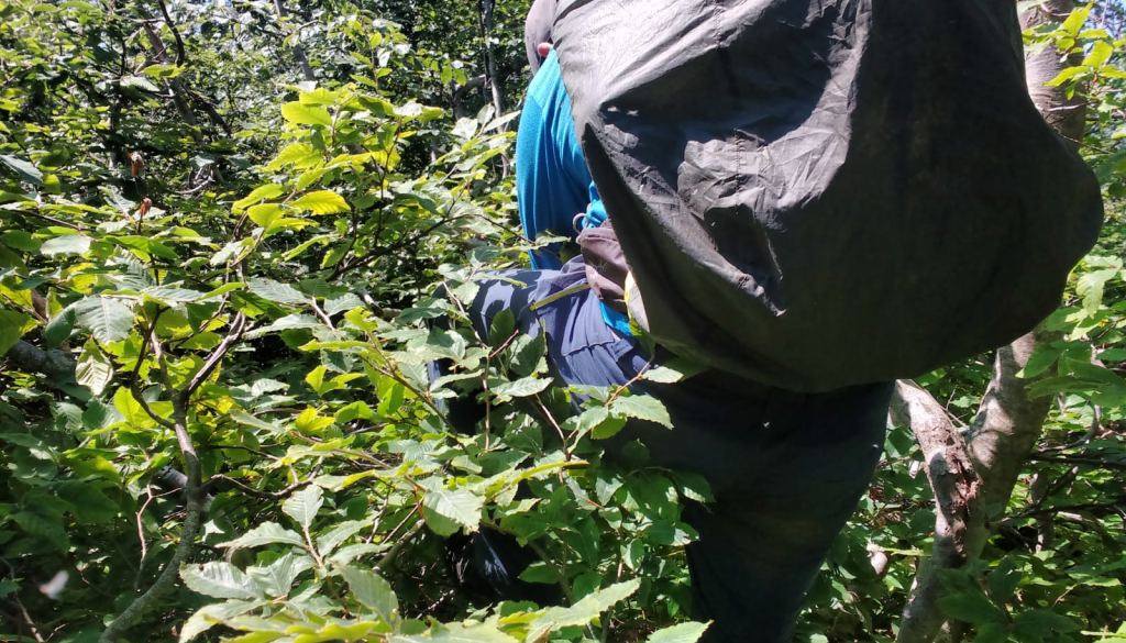
When I think of what ‘overgrown’ means in trailbuilding terms, tick-infested alpine meadows or a disused trailbed covered in blackberry bushes are what come to mind. That’s not what this area had to offer. Mtirala adds another dimension to the word. Much of the brush is little higher than head height, yet grows diagonally out of the slope, centimetres apart, and often as thick as your arm, which makes it difficult to actually place your foot on the ground.
Wanting to delay the bushwhacking as late as possible, I decided to scramble across steep granite faces on a crumbling ledge barely wider than my foot. Lea took the safer (and likely more intelligent) route of bushwhacking across a steep slope to meet me on the other side. We found, and soon lost, a trail, spent an hour covering just one kilometre, then unexpectedly popped out into a small clearing, which made a perfect camp spot under a clear night sky.


The following morning was more successful. We found the remnants of an old Soviet-era jeep track tracing the ridgeline that merged with a creek, eventually flowing through a small abandoned settlement. In the afternoon, however, things went haywire.
The route towards Mount Gvantsa was always up in the air. When planning it, I found no information on trails in the area, neither from Soviet maps nor Google Earth. I had hoped to find some animal trails heading along the ridgeline, but we had no luck.
For three hours we ascended through bushwhacking terrain, covering only about a kilometre. Two dozen mouthfuls of midges and some very sore shins later, we reached the first peak by scrambling up overgrown rock. The view towards Gvantsa – the next summit a few kilometres away – revealed more of the same bushwhacking territory. This brought the demoralising realisation that we were going to have to turn back. We were here to scout a route for a future trail, yes, but without a bulldozer at our disposal it was a non-starter. We made our way back to the settlement and banged out a rapid descent of 1,500 metres to the nearest road.

The following morning, Lea smashed a 20km road walk in a few hours so as not to break her thru-hike, whilst I hitchhiked ahead to the next village, ate some khachapuri and ice cream, and drank cha-cha with locals. I was enthusiastically told by a local family that reaching the summit of Mount Chakvistavi was ‘no problem’, bar a little overgrown trail near the top. Continuing towards Mount Makhunseti was apparently going to be impossible, but we decided to give it a go as some trails had actually been marked on OpenStreetMap.
We started losing the light as we reached the summit of Chakvistavi. We hadn’t carried much water up with us, so in the hope of finding a spring we found ourselves slipping around through thorn bushes to the nearest marked creek to fill up a total of 14 litres between us. By chance we stumbled across an old cabin in the process of being reclaimed by the forest, and decided to spend the night there as the forest was too dense to set up our tents.


In the morning we relocated the old trailbed. For the first time on the trip we were making real progress as the trail conditions gradually improved. On reaching Kharkhanisi, with only 15 kilometres of ridgeline left, we were forced to turn back as the trail began winding down the mountain towards the highway. We made our way back to the previous peak, Didi Tirala, to take shelter from a storm in some abandoned houses that we had passed earlier. After a two-hour afternoon nap in beds covered in mice droppings, we ventured out into the drenched forest to cross the final hurdle of Mtirala National Park before the final 15km road walk to theBlack Sea – and more importantly, ice cream!
That final obstacle was to connect some known trails detailed on OpenStreetMap via a mountain pass which apparently had an old 4×4 track running the length of it, as indicated by the Soviet maps. Our previous experiences meant that we were sceptical of its existence – or rather if the trailbed did in fact exist it would likely be engulfed by the forest. Despite having three hours to cover a mere distance of 700 metres across the pass, what followed was one of the most challenging experiences I’ve had in the mountains. The vegetation was the thickest we had encountered so far and was growing perpendicular to the direction we were attempting to walk in, meaning we barely covered 150 metres in an hour. It’s a frustrating, demotivating experience knowing that the trailbed could potentially be just five metres away from you at any time but be impossible to notice until you step on it. We searched and searched, but had no success.
With no possibility of turning back we descended into the canyon, scrambling and sliding down small waterfalls; both of us conscious that this was idiotic to attempt in such wet conditions. On reaching the valley floor we looked at each other, both battered and bruised and without saying much, evidently sharing an equal dread of the ascent that was to follow. Lea lead the first half of the ascent up a soaked 60° slope, grabbing onto plants and trusting them to hold our weight. Adrenaline carried us up the final hundred metres of ascent to the old trailbed, where in mild disbelief we set up our tents to the distant drone of beach music from Batumi, which was now only 20 kilometres away. We rewarded ourselves by sprinkling crumbled Doritos on top of the hikers’ delicacy of spaghetti and ketchup.

The final day was a lot more relaxed as we stopped for our long-awaited ice-cream, walked half of the distance in flip flops, and consumed all the remaining Snickers bars that had been squashed in our bags. Lea was experiencing the customary thru-hiker dilemma of being excited to reach her goal of walking to the Black Sea, yet not wanting the journey to end.
These scouting trips have a habit of never being as successful as you hope, but progress is progress, and at least we know that there is a passable route through Mtirala National Park. It might not be an entirely pleasant hiking experience as of yet, but the potential is there – and bad days in the mountains still beat the best days in the office. Let’s see what happens!


