
Day Hikes from Mestia
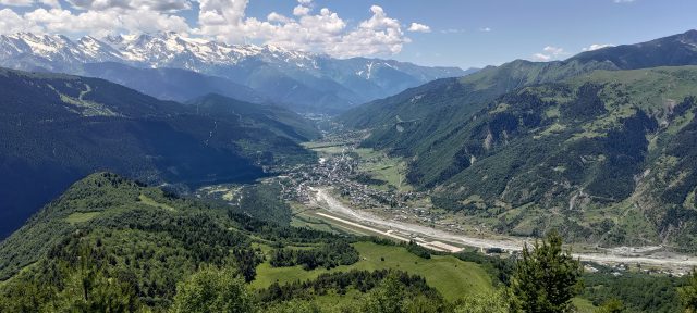
Mestia, the largest town the Svaneti region, is the only place with direct connections to major cities in Georgia, and is therefore the main hub for tourism. Situated at the midpoint of the Svaneti section of the Transcaucasian Trail, the town boasts numerous restaurants and guesthouses, several museums, and taxi drivers waiting to take you to the popular nearby attractions. Whether Mestia lies at the beginning, end, or middle of your hike, spending a day or two exploring the town is highly recommended.
All of the side trails on this page commence from Mestia’s town center, unless otherwise noted.
Jump to:
The Cross Over Mestia
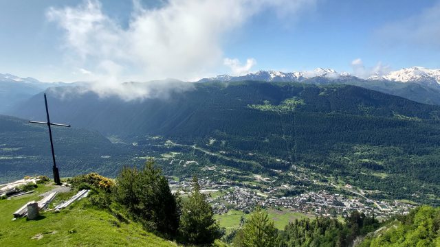
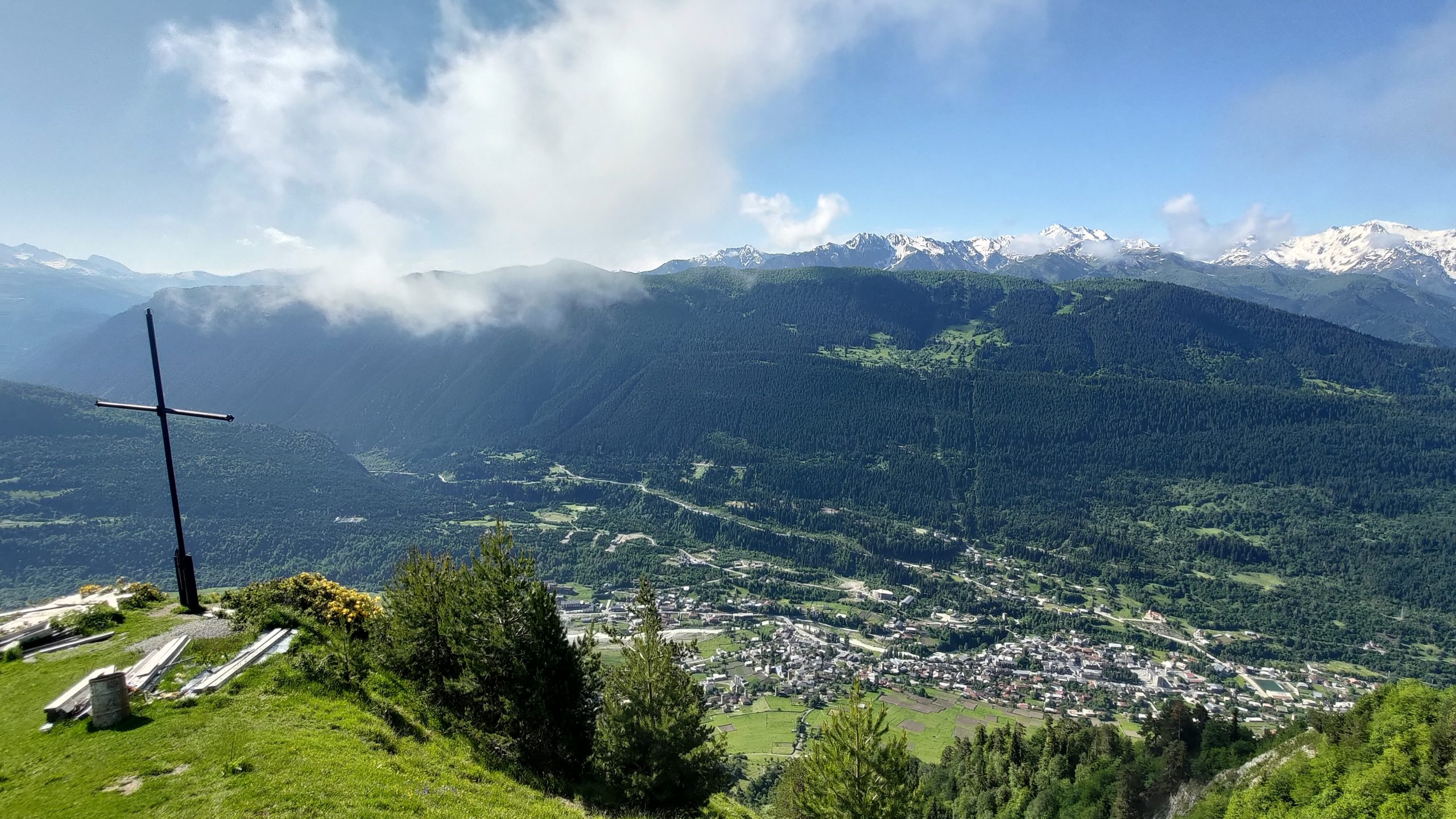
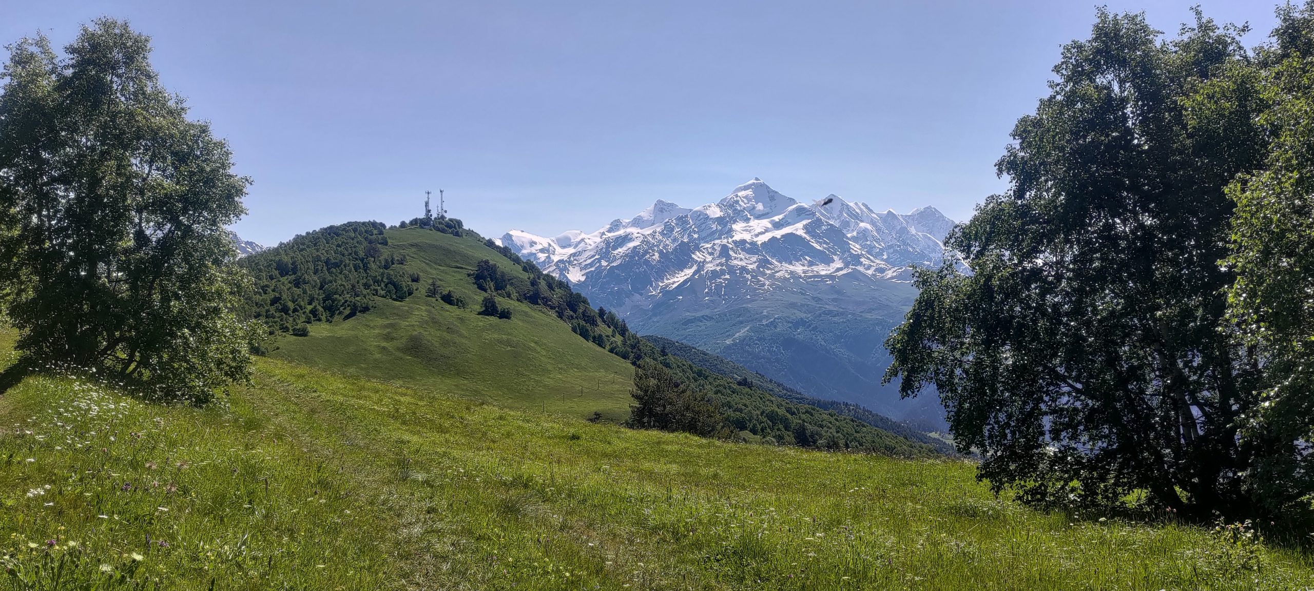
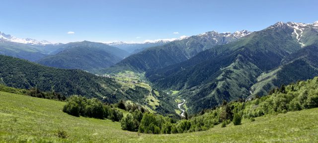
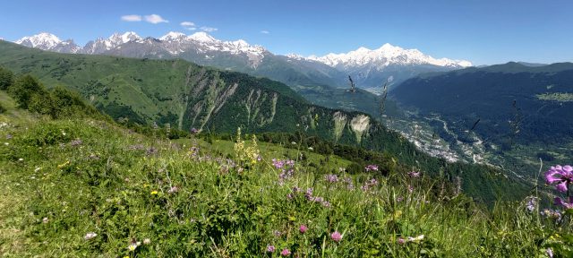
Hiking to the Cross Over Mestia is the quintessential activity for visitors to Mestia. The cross stands on a mountain approximately 700 m above the town, and those who make the steep journey to the cross on a clear day will be rewarded with a spectacular panoramic view of Mestia and the (often snowcovered) mountains beyond. Three main routes take you from the town center to the cross. We have listed them below, so you can follow one route both up and back or mix and match Route 1 with either Routes 2 or 3 for a circular route. Although Route 1 is the longest, is is much less steep than the other two.
Route 1 (yellow signs)
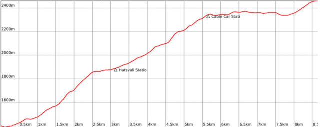
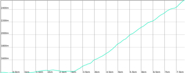
Overview
Distance: 4.5 km
Approximate Time: 2.5 hours
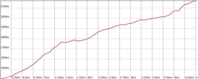
Elevation Gain/Loss: 785 m / -20 m
Difficulty Level: Medium
Max/Min Altitude: 2171 m / 1400 m
Elevation Profile
Route Description
The traditional route is easy to follow, and takes you up the mountain along gravel and dirt roads. Begin at the yellow sign in Mestia’s town center, and follow the road through the cobblestone streets of Lanchvali village. The road leads straight up, and when you get out of town, you’ll see another sign indicating the trail to the right, leading to the cross.
The gravel trail climbs up the mountain, and after about 300 m, look to your right for a wonderful view of Mestia. The trail continues up, crossing some small streams along the way. When the trail exits the forest into a meadow, you’ll see a fence along your left side. Follow the trail and the fence about 100m until the trail intersects with the road, where you will see a small wooden house on your left and white and red directional signs on your right.
Turn left on the dirt road, and follow it until you come to a large meadow on the hillside to your left with a fence enclosing a large part of it. You will see a red arrow pointing ahead. Here, you have two options. Either continue following the road, or turn at the small path leading up through the meadow.*
*If you choose to go through the meadow, follow the small trail up until it intersects with another trail. Turn left, and follow this trail. When you reach the fence on your left, watch for the sharp right turn of the trail. Continue following the trail until you reach the road again, and turn left.
Continue on the road until you see the cross and a viewing platform.
Route 2
Overview
Distance: 2.75 km
Approximate Time: 2.5 hours
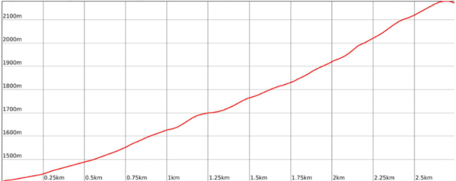
Elevation Gain/Loss: 775 m / -9 m
Difficulty Level: Medium
Max/Min Altitude: 2171 m / 1400 m
Elevation Profile
Route Description
Begin at the yellow sign in Mestia’s town center pointing to Koruldi Lakes, and walk straight up along the cobblestone road through Lanchvali village to the fork. You’ll see a yellow sign directing you to the right fork for Mestia Cross, but don’t take that route. Instead, continue straight, and the path quickly turns left.
Follow the trail up the mountain. It is pretty straightforward, and the red and white blazes make it easy to navigate. After about 500 m, you’ll reach a crossroads with a wooden sign directing you straight ahead towards the cross. (This sign serves as the junction for Routes 2 and 3).
Sometimes, the trail splits in two, but meets up again not too far away. As long as you are ascending and following the blazes, you’re on the right track. The trail is mostly gravel, with some dirt parts that can get a little muddy. Towards the end of the trail, the path emerges from the forest, and you will enter a clearing. Early in the season, there may not be a clear trail, so forge your own straight until you see the viewing platform or intersect the road. From the road, the platform will be on your right.
Route 3
Overview
Distance: 3.1 km
Approximate Time: 2.5 hours
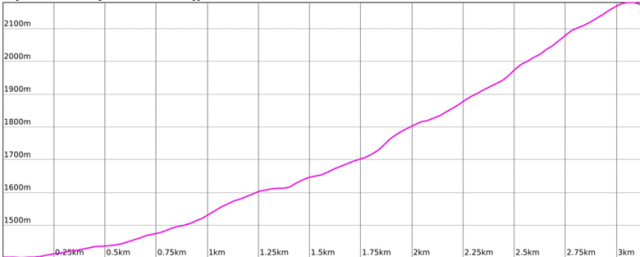
Elevation Gain/Loss: 780 m / -9 m
Difficulty Level: Medium
Max/Min Altitude: 2171 m / 1400 m
Elevation Profile
Route Description
This trail begins at Mestia’s town center. Walk along the main road a short distance and turn right on Vitorio Sela Street, just before you reach the store სუფთა სახლი (Clean House). Continue on this street until it intersects with a cobblestone road with a stream running down it. Turn right and follow the road for a short while until you see a trail just next to the stream. Follow the trail along the stream until the trail ends. Turn right on another trail, leading up a small hill. Turn right shortly after (you’ll see a clear trail and another one less clear – follow the latter). The trail turns left after about 200 m, and continues up the mountain, where it intersects with Route 2 after 600 m. Follow the blazed trail to the Mestia Cross and viewing platform.
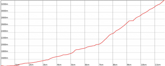
Chalaadi Glacier
Overview
Distance: 11 km
Approximate Time: 3.5 hours
Elevation Gain/Loss: 576 m / -56 m
Difficulty Level: Easy
Max/Min Altitude: 1925 m / 1400 m
Elevation Profile
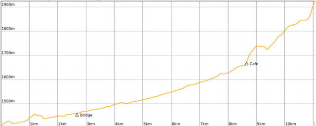
Route Description
This trail follows the road for the most part, with only 2.5 km along a forest trail. The road can be dusty during midday when taxis take tourists to the trailhead, and there is no shade along the road. Therefore, starting out early in the morning is recommended.
From Mestia, walk east along the main road. You will soon reach the outskirts of the town. When you come to an intersection, take the road with the bridge over the river and turn left on the road. Continue along the road until you reach a parking lot and another bridge crossing back over the river. This is the beginning of the forest trail.
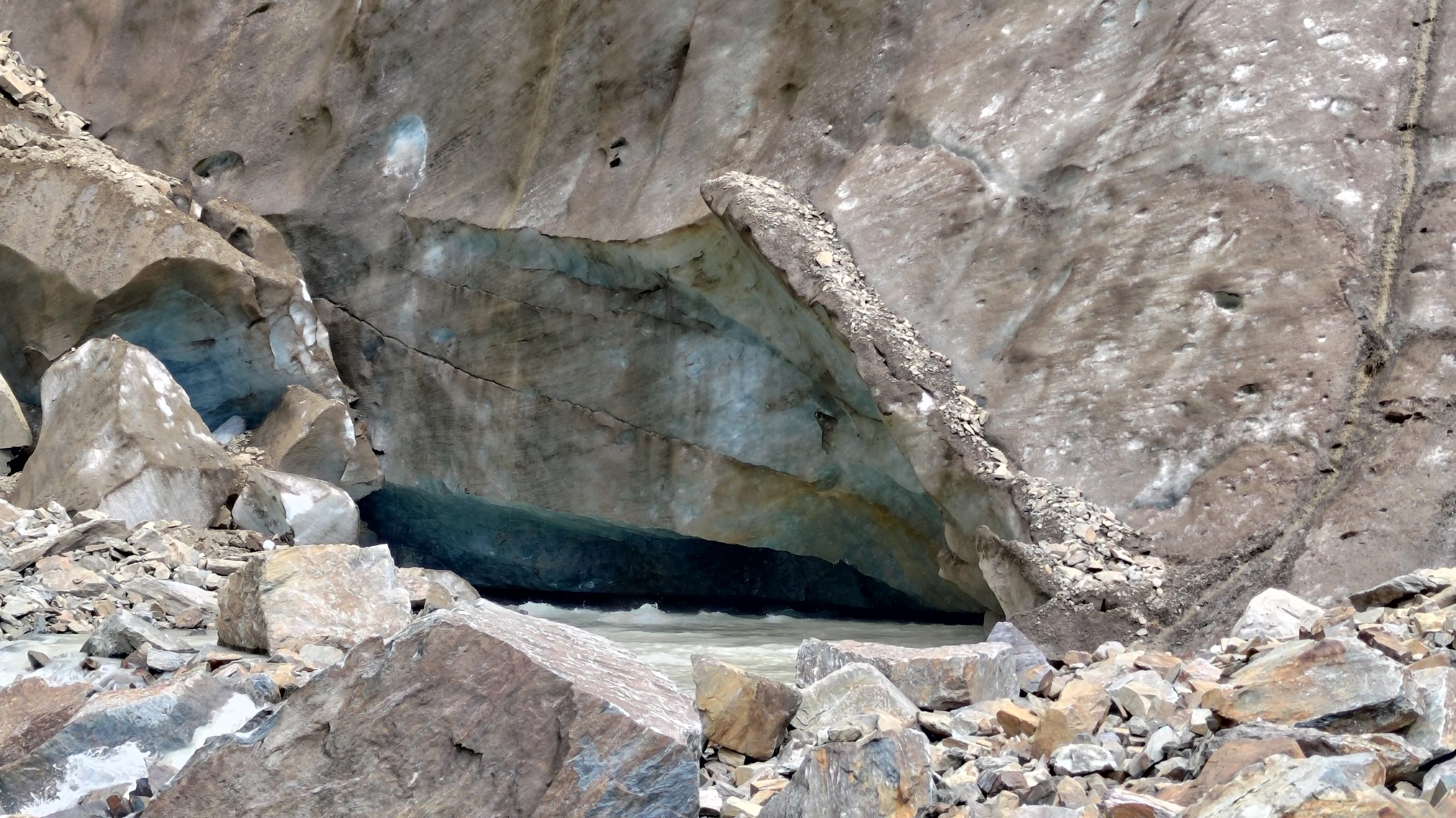
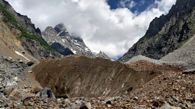
Once you cross back over the river, you will see a cafe and a sign pointing towards the glacier. Take the path leading through the forest. After about 770 m, the path begins running alongside a river to the left. At some points, the path may be wet. Continue along the trail through the forest, and soon it will open up and you will be able to see the glacier. The path is clear, and marked with cairns in spots.
Koruldi Lakes
OVERVIEW
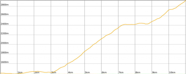
Distance: 6.35 km
Approximate Time: 3 hours
Elevation Gain/Loss: 1336 m / -3 m
Difficulty Level: Medium
Max/Min Altitude: 2741 m / 1400 m
Elevation Profile
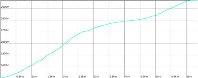
Route Description (from the Cross Over Mestia)
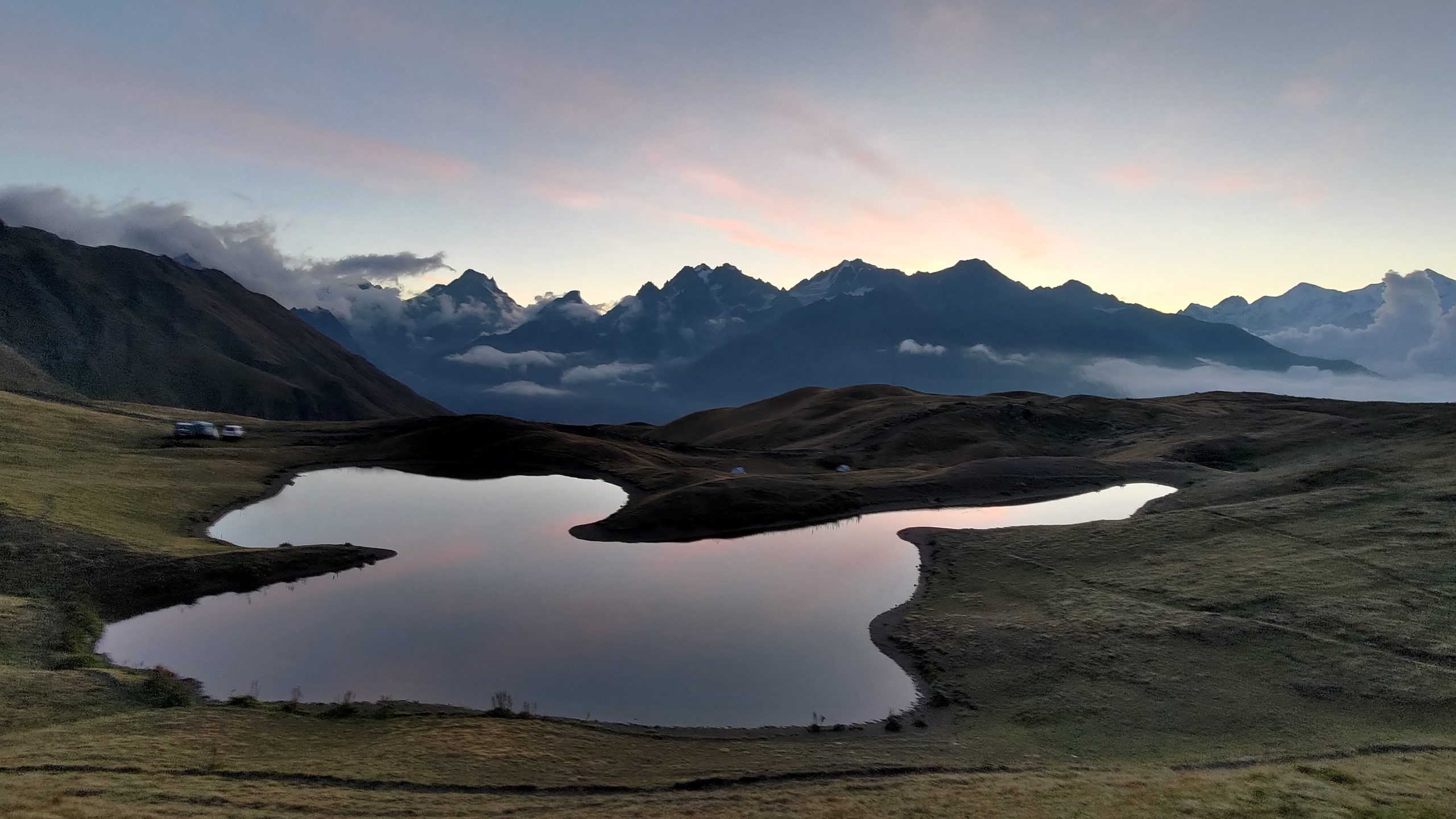
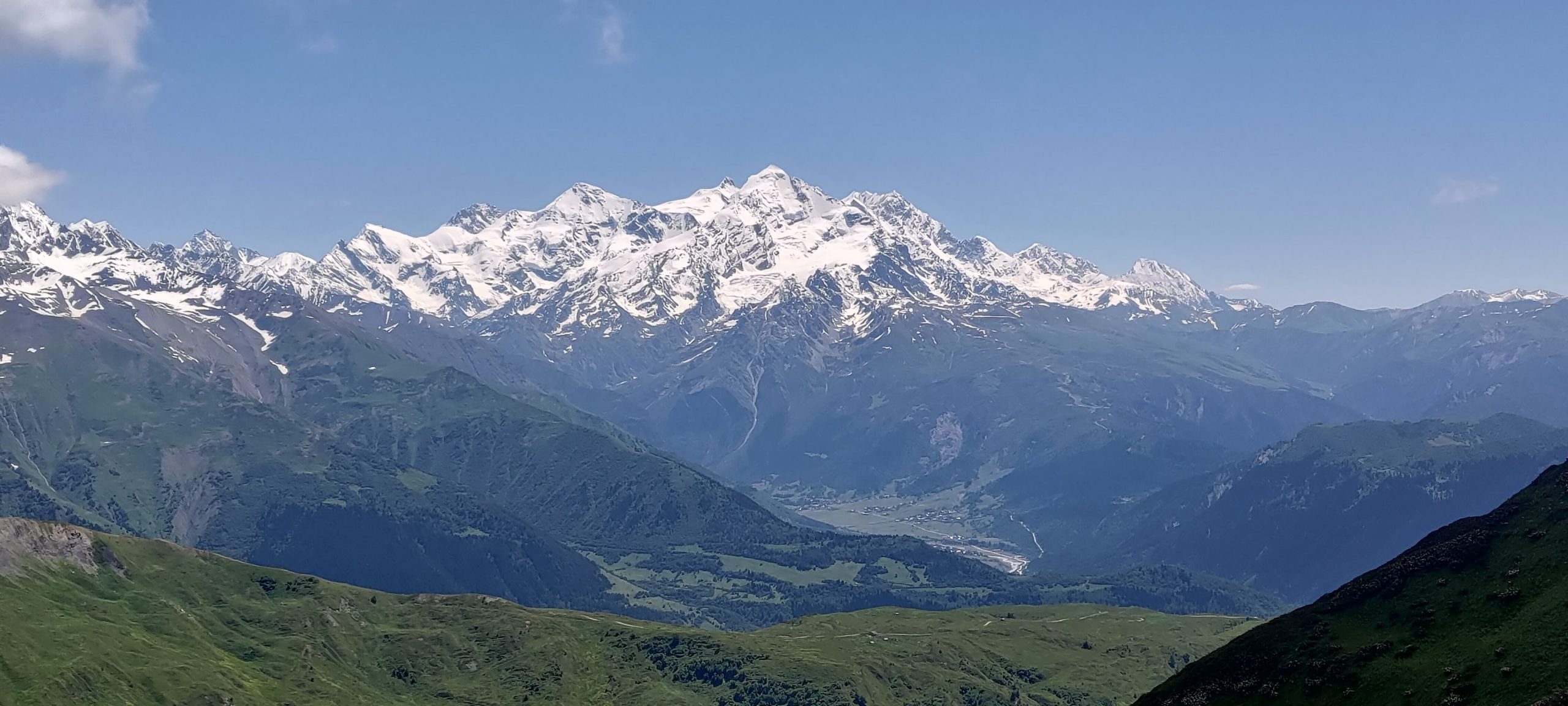
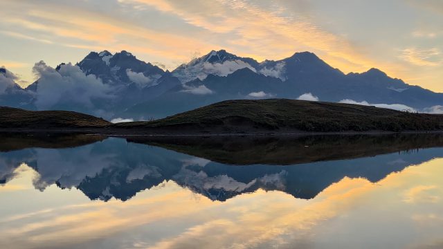
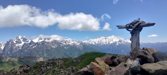
From the Cross Over Mestia, the trail to Koruldi Lakes continues up towards Mt. Ushba. The lakes themselves are small, and swimming is not advised. However, the views from the lakes make the trek worthwhile.
From the Cross Over Mestia, continue up on the jeep track. You will pass a cafe on your left, which is a lovely spot to take a break and enjoy the views of the mountains over a cup of coffee. The road splits just after the cafe, but as long as you are ascending, you will reach the lakes. Soon you will see a newly constructed house with Ushba as a backdrop, and if you are using Maps.me, Gaia, or another app to find your way, you will see “Lake Georgia” labelled on the map nearby. This “lake,” however, is overgrown with vegetation and not quite the quintessential lake you might be expecting. A little further down the road, you will pass by another semi-lake that is slightly easier to recognize as a lake.
Just past this lake, you will see a signpost with arrows pointing up towards Koruldi Lakes and across towards Guli Pass. Follow the sign towards the lakes, and be prepared for the walk to take a little longer than the 35 minutes the sign claims. Soon after the sign, you will see a path to the left of the road. You can either take this path or continue following the road to the lakes. If many cars are on the road, the path will be more enjoyable and less dusty. Both ways are just as steep.
When the path levels out, the first lake comes into view. You will find many spots for picnicking, camping, or simply enjoying the views. When the weather is clear, the lakes are a particularly excellent spot to see the sunset and sunrise. Return to Mestia along the same path.
Zuruldi Ridge
Overviews
From Zuruldi Cable Car Station
Distance: 3 km
Approximate Time: 1 hour
Elevation Gain/Loss: 178 m / -60 m
Difficulty Level: Easy
Max/Min Altitude: 2462 m / 2336 m
From Mestia
Distance: 8.65 km
Approximate Time: 4 hours
Elevation Gain/Loss: 1134 m / -75 m
Difficulty Level: Medium
Max/Min Altitude: 2464 m / 1400 m
Elevation Profile
Route Description
This is perhaps the easiest hike in Mestia, due to the ability to reach Zuruldi Ridge by cable car. The cable car station has inconsistent hours, but usually runs from 10:00 to 16:00, and a roundtrip ticket costs 20 lari. For those wanting an earlier start, hiking to the ridge is also possible.
By cable car
To reach the cable car station from Mestia’s town center, head south from Seti Square and cross the river. You will see a yellow sign on the road pointing left towards Adishi. Turn right instead, towards the Svaneti Museum of History and Ethnography. After you pass the museum, turn left at the junction, and follow the road a short while past a few guesthouses. At the second right, you will see a sign indicating the cable car. Turn up this road, and the cable car station will be on your left. Take the cable car to Hastvali, the next station. Get off here, and walk down the road a short way to the ski lift station to take the ski lift to the top of the mountain. Your ticket is good for both lines. You will disembark next to Cafe Zuruldi, which offers lovely views from the patio of the mountains.
By trail from Mestia
Head south from Seti Square and cross the river. You will see a yellow sign on the road pointing left towards Adishi. Turn right instead, towards the Svaneti Museum of History and Ethnography. Just after you pass the museum, you will see another yellow sign pointing to a trail on your right towards Hatsvali and Zuruldi Ridge. Take this trail as it ascends away from Mestia, and enjoy the views of the town. The trail enters the forest, and becomes wet, muddy, and unpleasant for a short while, even in dry weather.
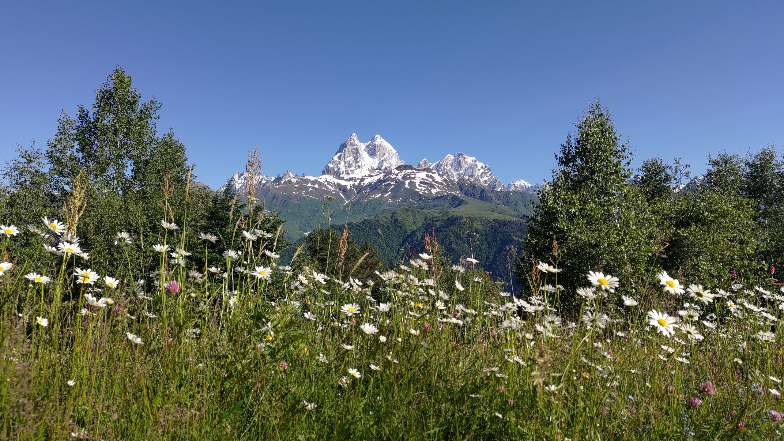
Soon, you will come upon a clearing with a bench and a view of Ushba, before intersecting with a road. Turn right and make a quick left up another dirt road. Follow the road for about 150 m and turn right on a trail. The turn is unmarked, so be sure not to miss it. The trail ascends to another road, leading to the Hatsvali Ski Lift. Go straight for a very short while, and turn off the road to follow a path to the chair lift. From here, follow the yellow sign towards Zuruldi. The path leads up the mountain, and soon you will encounter switchbacks leading you under the ski lift to the top of the ridge. After about 2.3 km, you will reach the top of the ridge and see the ski lift in front of you. Go to the entrance of the ski lift, from where the trail along the ridge begins.
Zuruldi Ridge
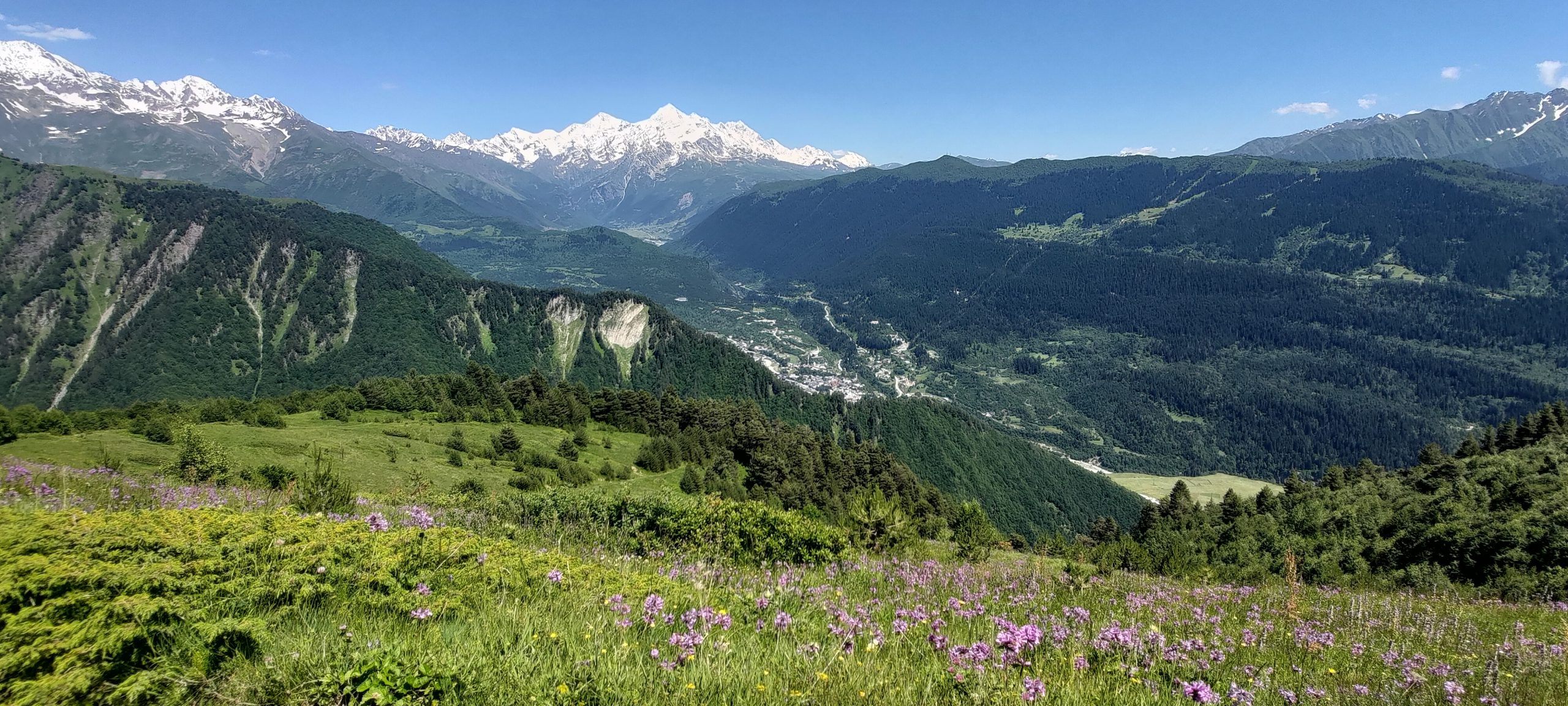
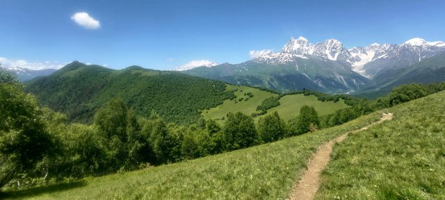
The trail heads east from here, and is easy to follow along the ridge. You will pass through trees and meadows, and have views of the mountains to the east, west, and south. After 3 km, you will reach the Mentashi viewing point, from which you can see the mountains of Ushba, Tetnuldi, Banguriani, and surrounding peaks. This is the popular turnaround point for day hikers, but the trail continues east towards Mt. Zuruldi, which is an excellent extension and less crowded than this section of the trail.
Mt. Zuruldi
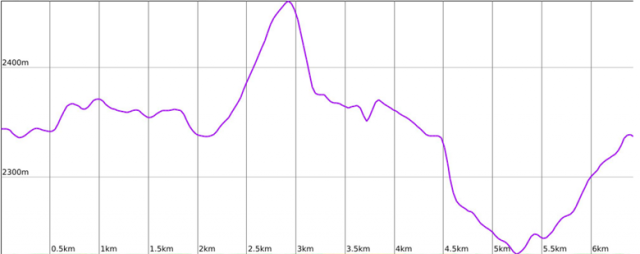
Overview (from Mentashi Viewpoint on Zuruldi Ridge)
Distance: 6.4 km
Approximate Time: 2.5 hours
Elevation Gain/Loss: 312 m / -319 m
Difficulty Level: Easy
Max/Min Altitude: 2461 m / 2230 m
Elevation Profile
Route Description (from Mentashi Viewpoint on Zuruldi Ridge)
From Mentashi, the trail winds steeply down for a short while before levelling out into a meadow. The steep part does not last long, but its grade can make it quite difficult, especially in muddy conditions. The trail through the meadow is pleasant and relatively flat, and you will be able to see Mt. Zuruldi in the distance. Continue along the trail, and after a couple kilometers, you will encounter another yellow directional sign. Turn right at the sign to go to the peak of Mt. Zuruldi. A church stands at the summit, and a meadow below offers views of Tetnuldi.
You can either return to Mestia the way you came, or return to the trail below Mt. Zuruldi and continue towards the village of Tsvirmi.
Mt. Lakshvid
Overview
Distance: 7.86 km
Approximate Time: 4.5 hours
Elevation Gain/Loss: 1200 m / -58 m
Difficulty Level: Medium
Max/Min Altitude: 2545 m / 1400 m
Elevation Profile
Route Description
This trail begins in the village of Lemsia, approximately 4 km east of Mestia. To reach Lemsia, walk along the main road from Mestia or hitchhike. Hitchhiking is easy and safe in Svaneti and because of the high cost of taxis, is quite common.
Turn right at the first road in the village, and the road quickly turns into a trail that winds up behind the village. The trail widens into a dirt road with several trail offshoots. When you reach a clearing, make a sharp left on a trail. Follow this trail as it ascends through the forest. Soon, you will see a meadow on your right and then enter the forest again. After about 1 km, you will have reached the treeline, and will be able to see Mt. Lashkvid in front of you; it looks like a large hill. As you approach the summit, you can turn off at any time to create your own path up. The way is steep, but quite manageable.
Mt. Gul
Overview
Distance: 11 km
Approximate Time: 6 hours
Elevation Gain/Loss: 1623 m / -85 m
Difficulty Level: Medium
Max/Min Altitude: 2923 m / 1400 m
Elevation Profile
Route Description
The summit of Mt. Gul can be reached from both Guli Pass and the trail to Mt. Lashkvid.
From the trail to Mt. Lashkvid:
From the turnoff for the Mt. Lashkvid summit, continue straight on the trail in the meadow around Mt. Lashvid . The trail soon enters the forest and remains relatively flat. The ascent continues as the trail opens back up into meadows. The trail follows the ridgeline up and around a bunch of large boulders to the summit.
From Guli Pass:
From the sign at the saddle, continue straight on the trail up the mountain. The trail will meet a rocky patch, but the rocks are secure and relatively easy to navigate towards the summit. After the rocks, you will see a trail winding up past the summit, but turning back around and leading you to the summit, where you will find a cross and a lovely view of Ushba, Laila, and other surrounding mountains.
Chkhuti Ridge
Overview
Distance: 11.7 km
Approximate Time: 2 hours
Elevation Gain/Loss: 1953 m / 20 m
Difficulty Level: Difficult
Max/Min Altitude: 3353 m / 1400 m
Elevation Profile
Route Description
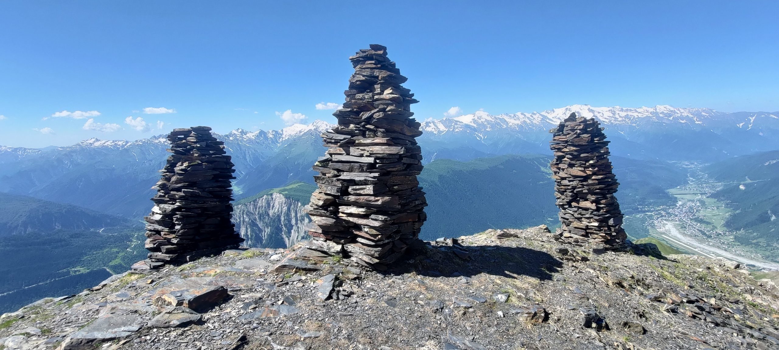
The trail along Chkhuti Ridge takes you up the side of Mt. Banguriani and offers stunning panoramic views of the nearby peaks. The trail is steep and unmarked but well-maintained and easy to navigate, and therefore, well worth the effort.
From the park in Mestia’s town center, walk southeast down the road leading toward the river. Cross the bridge just past the Turkish restaurant and Dissident Kitchen, Bar & Hookah, and turn left at the map and signpost immediately after the river.
At the first fork, turn right in the direction of Hotel Tetnuldi, which is above on your right. Continue on the road for about another 500m and bear right at another fork, toward Hotel Banguriani. Follow the road straight for another 2 km as it turns to dirt.
Near the end of the road, a white sign points to a footpath that leads up to the right. The climb here is quite steep but brief, and ends at a junction with a road. Turn right, and when you see a meadow on your left, turn into the meadow. The trail leads you up through the meadow and after a kilometer, turns to the right. Continue for approximately another 500 m before turning left into the forest. From here, the path winds up to the ridge and meets the treeline. Continue climbing steadily up, but don’t forget to turn around for a gorgeous view overlooking Mestia. When you reach 2700 m, there is a small peak, which can be a good turning point, but the trail continues on even higher for better views. From here, you should be able to see tall cairns in the distance ahead of you, which are what you are aiming for. When you reach about 3060 m, you will meet the three cairns and a spot that is good for a rest and snack break. The trail continues further up to two more sets of cairns along the trail. In early July, there are still snow patches at this elevation, so be prepared.
