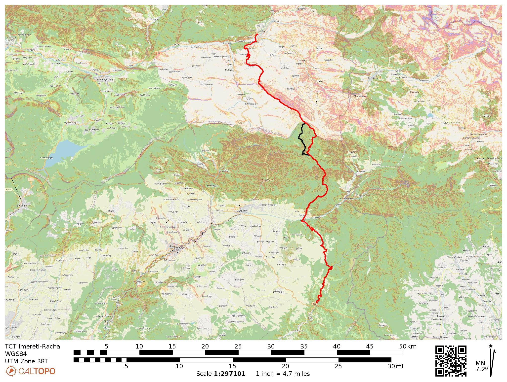
Map & Trail Notes
Quick Facts:
To download this route in GPX or KML format for GPS devices and smartphone apps, visit the interactive map on CalTopo.com and click the “Export” button.
Trail Notes
Note: The route is described from south to north, but can be hiked in either direction.
The Tbilisi-Sackhere Road to Drbo (23km, +550m/-775m)
This section of the Transcaucasian Trail begins rather unceremoniously: From the main road that connects Tbilisi with Chiatura and Sachkhere, jump off at the point where the GPS track begins.
Follow a paved road up a steep hill. Soon, the pavement flattens out and becomes a dirt track.
Continue to follow this road north. It’s an easy walk on a dirt road through forest and fields: flat and extremely simple to navigate.
After 3.5km, you’ll pass a building with a water tap near the road, a good chance to fill up.
At about 7km, you’ll pass a small stream, and if you listen closely, you’ll hear the distinctive trickle of a waterfall. If you turn off the trail and bushwhack up the stream for a few dozen meters, you’ll find a nice small waterfall in the forest, which makes for a nice cool resting spot.
Back on the road, after another few hundred meters, you’ll come across another ideal resting spot: a makeshift picnic table with a spring. Fill up (this is your last opportunity for several kilometers) and take a rest here, because the climb is about to start.
Continue on the road for another few dozen meters, keeping an eye out for a path turning sharply uphill and to the west. When you see this turn, take it: do not continue along the main dirt road. You’ll gain a steep 200m of elevation before the trail flattens out, granting you nice views over Imereti’s valleys and woodlands and gentle climbs for the next few kilometers.
After another 3km, you’ll pass a shepherd settlement and farm. Pay close attention to the GPS track here, as one branch continues north and you want to veer northeast.
Continue following the dirt track through farmland, enjoying the pastoral and forest views around. After another 3km, on the west side of the track, there’s a small offshoot that leads to a hut and a well. The well water is drinkable, although to be extra cautious you may want to treat it first. If you’re feeling uncertain, this is the first of several water sources you’re about to encounter if you’re heading north (and your last if heading south until you hit the picnic table spring).
Shortly after the well, the track becomes a much more well-used dirt road. Just as the road makes a sharp U-turn and starts to veer downhill, there’s an intersection in the forest. If you follow the small track north, you’ll find an old church with a lovely interior, complete with nearby picnic tables and water. This area would make an ideal campsite, although you might find yourself sharing it with local picnickers. After this, you’ll shortly reach the town of Speti and campsites will be limited until you pass Drbo.
Return to the main road and continue following it downhill. You’ll pass a few springs on the way. As you reach the upper part of the town, the road becomes asphalt. Continue following this road all the way down to the river that separates Speti and Drbo.
Cross the main bridge. As you enter Drbo, you’ll find a small shop selling basic supplies and ice cream immediately on your left.
There are no guesthouses in Drbo, but there are a few in Sachkhere, which is a 20 minute drive. Depending on what time you arrive there might not be many cars going along the road, but with some luck you’ll be able to easily hitchhike.
Drbo to Oni (51km, +2540m/-2280m)
From the Drbo shop, turn north and follow the road on the west bank of the stream that runs through the village for 1.4 kilometers. Look for a turn towards the northeast where cars drive through the stream. Turn here, and look for a footpath following the west bank of the stream.
Be prepared for several stream crossings in this section. The path mostly hugs the west bank and there are a few small footbridges, although you will still have to cross the stream back and forth a few times.
Roughly 2 kilometers after turning off the main road, you’ll see a nice camping spot in a flat field close to the river. This would be a good place to spend the night if you’re arriving late.
After another 2 kilometers, you’ll pass a shepherd hut with a nice picnic shelter, which is sometimes used by locals. The fields around the hut are also open and would be nice for camping (of course, you should ask permission if anyone is nearby). There is a spring nearby– continue a few hundred meters on the trail (which is now a jeep track and can be quite muddy after rain). Where the jeep track turns a corner and heads east, look about 10 meters upstream for a small spring piped from the ground.
You would be wise to fill up here– after this, you will pass a few other small streams and a few very small springs along your way over the ridge, but this is the last piped spring until Korta. In addition, there are other water sources noted ahead that you can treat, but they are unreliable in the second half of the summer and autumn. The bigger sources– e.g. the large stream up high on the ridge near Skhmeri– should be running. The other sources were small in early July 2022 and dried up a few weeks later.
Continue on the jeep track. Another 2km after the spring, you will pass another field that would make a good camping spot if needed. There is a seasonal stream a little ways ahead.
500m after this field, you’ll come to an intersection. Turn slightly left instead of continuing to follow the main jeep track. The path will lead toward a stream and follow a nice singletrack through the forest. However, although the singletrack path continues, look for a sharp switchback turning uphill to the left. Instead of following the path along the bank of the stream, you need to turn uphill and start climbing.
Now the real climb starts, as you start to gain elevation through a beautiful old forest. Soon you’ll come by the remains of an old building partially taken over by the forest– a nice spot for a break.
Continue along the path to the west of the ruins. It will take you on a nice stretch of singletrack through rhododendrons. Soon you’ll turn to the west, crossing a stream (running on July 7, 2022). Aside from a few small seasonal streams, this is is your last chance to fill up with water until you get up high on the ridge towards Shkmeri.
Shortly after the trail gets somewhat overgrown, then rejoins an intersecting network of jeep tracks. Turn north. The next 4 kilometers are a relatively steep climb, but the path is clear.
After you reach the ridge, you’ll start gently dropping down into the next valley. After a kilometer you’ll pass another flat spot that could be used for camping (and clearly has), but which has no water source.
About a kilometer after that flat spot, you’ll come to a jeep track intersection. Follow the track continuing straight. If needed, at this intersection there is an alternate route that veers slightly west and goes down to the bottom of the river valley. If it is a dry season and you need water, this can be a good alternate instead of going straight up to the ridge; this jeep track rejoins the ridge at a later point, but you’ll add more climbing and skip some of the first great views. Unless you need water, continue along the ridge track, soon turning towards the northeast.
Get ready for the next climb: From this ridge, you will continue northeast and gain 300m of elevation quite quickly. This time you’ll be well-rewarded, however; you’ll crest above the trees and get sweeping views of the plains stretching south through Imereti.
Once you reach the top of this ridge, the trail becomes much less steep, instead following the contour lines of the ridge along some singletrack and animal tracks that weave in and out of the forest. Shortly after you pass a ruined shelter, you’ll turn towards the northwest to continue to follow the ridge. As you follow the curve of the ridge, earlier in the year you may find some small water sources, but don’t count on this later in the summer or fall.
Soon you’ll climb out of the forest and come to a small meadow. Continue straight across. There are a few intersecting jeep tracks (one goes down to the river valley, which joins the other alternate path mentioned earlier), but you want to continue straight. You’ll pass a small farm.
One kilometer after the farm, and then again half a kilometer after that, you’ll pass two small seasonal springs on the ridge (running in early July 2022, not running in August 2022). They are both quite small and hard to fill up water bottles from; you’ll need something with which to collect water. There is a high likelihood that these sources will dry up later in the summer.
As you continue along the ridge, about 2 kilometers after the second spring, you’ll see a larger stream in the bottom of the small valley to the south. This is a more reliable source. You can also find nice camping spots near the stream in the wide and grassy terrain. This is a great spot to break up the hike. However, even though this area is slightly sheltered relative to the ridge, keep in mind that it is still quite high and exposed and would not be pleasant during a thunderstorm.
Continue following the ridge; the path alternates between following the top of the ridge and contour lines on the side. When the ridge widens out into more open terrain, the trail disappears into grassy wildflower fields, but it’s straightforward to continue following the ridge. Enjoy the wide views of the Greater Caucasus range to the north!
As you near the end of the ridge traverse, you’ll approach the distinctive King Tamar Cliffs. Keep an eye out for a small trail turning down below the cliffs on the northern side.
(If a bailout option is needed at this point due to bad weather or other emergencies, there are also some jeep tracks heading down the gentler slopes on the south side of the cliffs that go to the villages of Skhmeri and Usholta.)
The small trail weaves through rhododendron bushes and traverses below the cliffs before turning north and beginning a steeper descent. At times it gets a bit overgrown, but overall the path is straightforward to follow. As you descend into the forest, you’ll begin to spot occasional orange trail flags; these are from the TCT crews who cleared and flagged the route in June 2022.
In the forest, the trail turns northwest– keep an eye out for the trail flags. The trail weaves through an old forest with widely dispersed trees, staying on small ridges where possible above the muddier lower ground.
Close to Korta, you’ll exit the forest into a beautiful clearing with an excellent view of the cliffs you just descended. (You may even see a wooden camp table crafted by the 2022 trail crews.) This would make a good spot to camp. There is no water directly nearby, but the spring at the top of the village is a short walk.
Continue to Korta. There is a spring immediately as you enter the village.
Follow the jeep track through Korta. It may be possible to hitch a ridge out from here to Oni, or you can continue walking along the dirt road. It is another 10km to the center of Oni. You’ll pass through the villages of Khirkhonisi and Komandeli along the way, both of which have springs.
Between Korta and Khirkhonisi, just off the main road, there is an excellent viewpoint with views of Oni, the surrounding mountains, and the river valley. It is a very short walk and highly recommended.
Continue walking into the center of Oni. Congratulations on finishing this stage of the Transcaucasian Trail!
Menu
Route Resources
Partners & Sponsors
This section of the Transcaucasian Trail was developed between 2021–2022 with the generous support of the U.S. Forest Service International Programs and individual donors to the Transcaucasian Trail Association.
To become a TCTA member and support more trail development projects like this one, join here.