
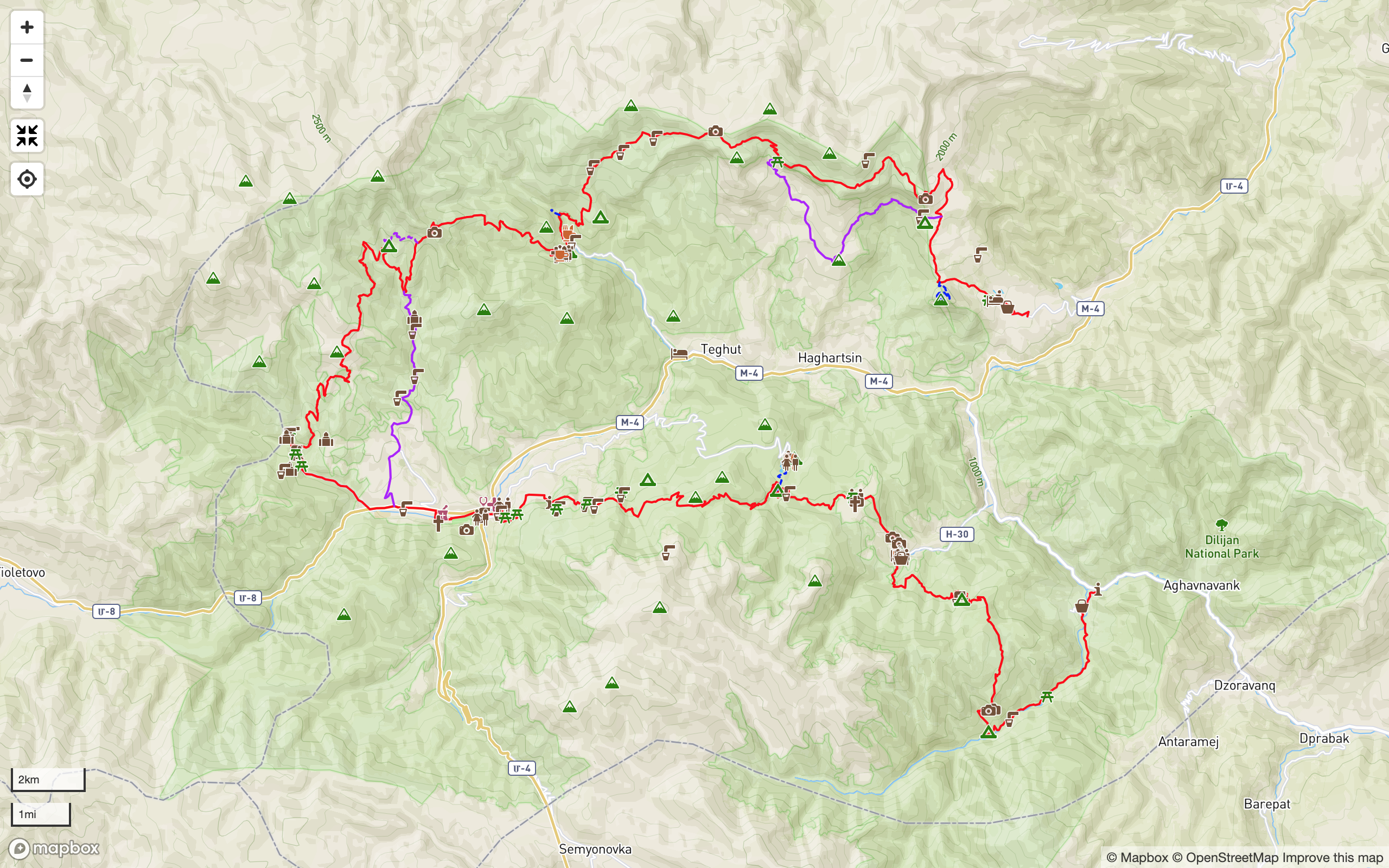
Map & Trail Notes
Quick Facts:
Elevation Gain/Loss: 4,316m/4,130m

Detailed Trail Notes
Note: The route is described from south (Khachardzan) to north (Hovk), but can be hiked in either direction.
Start: Khachardzan
Khachardzan is a small village 8km off the M4 main road that follows the River Aghstev between Dilijan and Ijevan. The main road is served by mashrutkas (minibuses) from Yerevan; drivers will set you down at the correct junction (signposted for Chambarak) if you make the request in advance.
Taxis are available from Dilijan, Ijevan or Yerevan. A private taxi from central Yerevan to Khachardzan (~120km) should cost 12,000-15,000 AMD. From Dilijan or Ijevan, prices should be negotiated in advance, but should be around 5,000 AMD one way.
From the M4 junction, follow the H30 provincial road up the Getik valley. Traffic is light, but hitch-hiking is relatively easy. Shortly after passing the roadside sign for Khachardzan on the H30, look for the bus stop on the right. Turn right here and proceed over the bridge and into the village on a dirt road. After 500m, turn right again and cross another bridge over the river. After 150m you’ll find a small shop on your right that sells groceries and basic supplies.
Bear left and continue 600m, following the main road S through the village in parallel with the river, passing a church on your left, and crossing the river again to reach a junction with another dirt road. Turn right on this road and follow it for 300m until it bears left and starts to climb. Take a right turn once again. Following this dirt road S will take you out of Khachardzan and along the valley floor into the forest.
Khachardzan to Gosh Lake (11km)
There are various side roads leading off the main track. Stay on the route closest to the river, which will begin to bear SW. You’ll shortly encounter a metal barrier and a sign board indicating the territory of Dilijan National Park, after which there is an unbridged river crossing. From here, a pair of large water pipes also act as a navigational guide for the first 1km or so until they terminate at a small Soviet-era weir. Rather than staying on the jeep track, follow the short waymarked sections of footpath on the north bank of the river to avoid any further river crossings.
3.8km after leaving Khachardzan, the road will begin to bear right and climb up into a small side-valley. Follow the hairpin bend through the stream crossing and continue to climb. You’ll emerge from the forest at the corner of an orchard. Continue alongside the orchard for another 250m until you see a signpost on the side of the road. Follow the direction indicated, walking 100m N uphill among the fruit trees towards a natural gap in the forest. The entrance to the trail will be clearly visible on your right.
This overgrown and long-disused historical trail between Chermakavan and the riverside orchards was explored, mapped and restored by TCT volunteers in 2017. You’ll follow it roughly N up a side valley and back into the forest for 800m before crossing the river and climbing steep switchbacks through dense overgrowth, ascending along narrow rocky escarpments until you emerge from the forest to be presented with magnificent views of the valley below. Continue following a gentler footpath through the forest until you emerge onto an open plateau. Follow the signposted route N across the hay fields until you reach the dirt road.
The road will lead you through the ruined village of Chermakavan, meaning ‘white church’ (also known colloquially by its former Turkish name Aghkilisa, which translates to the same meaning). It is easier to see the surprising extent of the village from a high vantage point; however sticking to the road will still take you past the ruined walls of some of the old houses. It’s worth making the short 100m detour to see the remains of the hilltop church on your right, together with its surrounding khachkars. Passing the village in late summer or autumn, you may find locals from Khachardzan making hay or harvesting apples and pears from the abundant trees which still bear fruit.
Walk 850m N past the church along the same main road until you re-enter the forest. After another 750m, you’ll come to a crossroads. Continue straight on in the same direction with which you arrived. The road will bear W and start to descend steeply. Following it straight downhill will take you to Gosh Lake via a very steep and rutted road, but better to look for the new trail on your left. This winding singletrack trail, built by volunteers in summer 2017, will take you on a much more gentle and natural route through untouched forest, bringing you out after 1km to a picnic area at the edge of Gosh Lake.
Gosh Lake is an obvious choice for hikers wishing to camp before arriving at Gosh village. It is, however, also a popular destination among locals for khorovats and oghi-fuelled evenings of revelry! You may wish to consider this before expecting a quiet, uninterrupted night in nature, especially in summer and early autumn…
Gosh Lake to Goshavank (Gosh village) (4.2km)
The trail continues from the NW corner of the lake towards Gosh. Follow the waymarkings carefully, being aware that the tangle of dirt roads near the lake can make this area confusing. After 600m of trail, turn right onto a short 60m section of dirt road, then turn left off the road down the marked trail. You’ll follow a small stream, make a small crossing, then continue through open woodland on restored footpaths.
750m after leaving the road, you’ll reach the edge of the forest, and follow faded dirt roads for 500m up the hillside and across hay fields, where you’ll meet another dirt road at a T-junction. Directly to your right, you’ll see a collection of khachkars beneath a tree, to which locals will have tied a flurry of handkerchiefs – a pre-Christian religious tradition that survives to this day.
From the sacred tree, proceed left and SW along the dirt road. Following this road through cluster of woodland and hayfields will take you on a gentle 1.8km loop around the valley above Gosh before descending into the village itself.
Goshavank (Gosh village) to Parz Lake (7.2km)
Walk uphill on the paved road passing the entrance to Goshavank complex and follow it round to the left. Turn right past the houses up a small footpath that runs alongside the village cemetery. Follow this path through the cemetery and through the wooded gorge until it reaches a small stream crossing after 220m.
Cross the stream and follow the trail steeply up and NE. Following this footpath up steep slopes will bring you to a rocky outcrop with natural rock steps and ledges. Ascending here will bring you to open ground, affording excellent views of Goshavank below. The remains of khachkars can also be found at this viewpoint.
Follow the signposted route uphill for 150m or so until you reconnect with a defined trail heading NW and up along the side of the ridge. After 300m, the trail will bear left and pass between a natural notch in the rock. After the notch, continue to follow the ridge directly uphill. You’ll re-enter the forest after 250m.
Follow the trail up through the forest for 700m. You’ll reach flatter land and eventually emerge from the trees below the ridge, on the edge of haymaking fields. Continue in the same direction for another 130m to reach a dirt road near an isolated tree and stone pile. Turn left on this road and follow it roughly W for 420m to reach a junction of six roads.
Follow the track NW from this junction (the second road on your right, if following the described route from Gosh). After 150m you’ll come across a covered picnic shelter on your right. Just behind the nearby trees you’ll also find a public toilet. From the picnic shelter, turn left off the main dirt road and follow the side road W past the electricity pylon.
Continue along the track that traces the edge of the forest for 250m, at which point the trail will start to penetrate deeper into the woods. After a short time you’ll cross a clearing with a single tree in its centre. Be careful to take the correct exit from the clearing as at least two trails are present here. The correct one bears roughly S and is clearly marked.
After another 100m or so, the trail crosses a dirt road at the edge of the forest, which will be on your left. Cross straight over and follow the winding footpath through the forest, which will begin to descend. After 150m you’ll cross a footbridge over a deep gully.
Follow the marked trail for another 2.2km down through the forest to reach the bottom of the valley and the junction with an old dirt road repurposed for hiking. Be aware that the route of the trail crosses several logging roads and takes several minor detours through the woods to avoid areas of recent logging. Avoid getting lost by keeping an eye out for the regular trail blazes and tags.
From the junction with the road, turn left and walk another 350m W, crossing a small yellow footbridge to reach a clearing. From here, proceeding NE for 1km along the road will bring you to the Parz Lake recreational area, where refreshments, accommodation and transport are available. Turning left and walking 60m SW along the road in the other direction will bring you to the entrance of the trail to Dilijan.
Parz Lake to Dilijan (13.3km)
If beginning at Parz Lake, follow the dirt road from the top of the complex for 1km to the clearing and the junction for both the Goshavank and Dilijan trails. From the clearing, follow the dirt road SW 60m from the signpost. The entrance to the trail to Dilijan will be immediately on your right and is marked with a wooden post.
Follow the trail into the forest, climbing gradually and skirting the edge of a lush plateau of grass and nettle. It is easy to lose the trail here during the low season when the vegetation has died down, so follow the markings closely. The trail will climb again, traversing steep sideslopes and making another switchback to gain a ridge, roughly 700m after leaving the junction with the road.
Continue following the defined trail along the gentle gradient of the ridge. The trail will begin to narrow and plunge into deeper forest on steeper slopes, climbing continuously. The construction of this trail by TCT volunteers in summer 2017 was one of the biggest projects of the year, requiring 6 weeks of work for a team of 15-20 people.
After another 700m you’ll ascend two switchbacks. Another 250m will bring you to rockier terrain. Follow the switchback up through the rock for 200m before the trail switches back once again. Another 150m of walking will bring you to a clearing with a fire pit and space for a small number of tents. There are no formal facilities here; if you wish to wild-camp, make sure to pack out your trash and bury any human waste according to the Leave No Trace principle.
The trail weaves across the clearing before continuing W, crossing two logging roads and ascending through well-preserved forest. After 1.7km you’ll reach a junction with an old logging track; turn right and after 150m left to continue on the newly built trail. After 300m or so, you’ll reach the edge of the forest, where the trail will bring you out at the bottom of a huge alpine meadow, known locally as Gyolort (reportedly meaning ‘place of wolves’).
Follow the signposts across the meadow to the high point near the NW corner of the field, where you’ll see the remains of Soviet-era water infrastructure in the form of a vertical pipe protruding from the ground – while ugly, it’s a useful orienting feature! Here, the trail crosses a dirt road. Walk N for 60m to find the entrance to the forest and the trail down to Dilijan. Follow the dirt road downhill NE for 250m, then take the side track on the left. Be aware that this turning may not be obvious at certain times of year due to undergrowth, and also because the main dirt road continues straight on at this point. After 170m, the route switches back to the right and continues for another 150m. As the road begins to steepen sharply, look out on your left for the entrance to a newly-built footpath.
Follow the footpath for 900m until you emerge on a logging road that runs straight up the hillside to your left. Bear very slightly left and cross the logging road, looking for the entrance to the continuation of the trail, which is opposite the trail exit behind you. This abandoned logging road proceeds down through the forest. Follow it past several small clearings until it begins to become more pronounced, eventually leading to a stream crossing after 650m.
Cross the stream and walk uphill for 120m to a junction of two dirt roads. Take the road to your right and follow it steeply down through the trees for 180m until it crosses a fast-flowing stream. Continue W for another 220m, following a rocky trail beneath a steep cutting to another broader stream crossing. Cross the stream and follow the road right and uphill; after 50m the terrain will flatten out and the trees give way to open land.
Cross the clearing, walk 150m over a rise in the road, and look out for the turning on your left. Follow this narrow trail for 650m along a pleasant wooded hillside, passing above one of Dilijan’s dairy farms. You’ll cross a stream by a spring in close proximity to the farm before continuing to meander W among trees and streams, as the land becomes ever more pastoral and inhabited. Another 300m will bring you to a picnic shelter and spring to the right of the trail; 300m beyond that is the junction with the dirt road to Dilijan.
Turn left onto the dirt road and cross the stream. A tangle of tracks traversing these hillsides will all take you to the same place, roughly 750m from the stream crossing, where the various roads converge into one and descend steeply E for 450m to the Takhta suburb on the edge of Dilijan. You will also see several signposts for other trails in this area, including the Skywalk Trail and the Panorama Trail.
Dilijan Centre via the Drunken Forest
There is a direct route to the town centre from here, but we recommend instead the scenic route through the ‘Drunken Forest’, which will bring you to Dilijan centre via pine forests, panoramic views, and many of historical Dilijan’s older remains.
From the trailhead information boards, follow the road down into the residential area. After 300m you’ll find a kiosk selling ice-cream on your right. After buying and eating an ice-cream, take the next left and walk 500m W along a straight residential road between houses.
Turn left at the first crossroads and follow the road up through gardens and orchards, bearing right at the fork after 230m, and continuing another 350m to a picnic site overlooking Dilijan. On the right you’ll find a footpath descending the hillside, which will cross a stream after 100m before bringing you to a clearing. Cross the clearing and enter the pine forest midway along its edge.
From the W corner of the pine forest, a trail descends towards the town centre. A route has been marked on a mixture of paths and old dirt roads; as long as you continue to descend, you should eventually find yourself on a flat, residential road passing between small houses and gardens.
Pass through the gate and continue straight, following two flights of wooden steps down and eventually emerging onto Myasnikyan Street besides a crumbling 19th-century townhouse.
Turning right here will take you to the commercial centre of Dilijan; crossing the road and turning left will take you past several of Dilijan’s more tourist-friendly establishments before eventually bringing you to the de facto centre of the town at the bottom of the valley, with multiple main roads leading out of town in the directions of Lake Sevan, Vanadzor and Ijevan.
Congratulations: you’re almost halfway through the trek!
Dilijan to Jukhtakvank (7.1km)
Starting in the centre of Dilijan, make for the NW corner of the traffic island, next to the Mimino statue and drinking fountain outside the souvenir shop. Follow Kalinini Street (signposted for Vanadzor) away from the roundabout and take the first left onto Getapnya Street, so you are walking W along the sidewalk parallel to the river, with the river on your left. Follow this boulevard for 900m, then cross the pedestrian footbridge on your left. Turn right off the bridge and continue 430m along the riverside with the river on your right.
Re-cross the river on a second footbridge. Cross the road and continue straight, away from the river and past the school on your right. Round the corner to the right at the end of this street and continue up to the main Vanadzor road. Make a sharp hairpin left on this road. If you’re hiking through to Hovk, the markets on this stretch of main road represent your last opportunity to stock up on supplies.
Follow the sidewalk along the main road for 1.3km. Cross the road at the junction by the bus shelter. Continue on the opposite sidewalk for a further 650m to the junction with Abovyan Street, where you’ll see signs for Jukhtakvank. Turn right at this junction and follow the broken asphalt road for 2.7km to reach the trailhead for Jukhtakvank.
Jukhtakvank to Haghartsin Monastery (19.8km)
From the trailhead information board, follow the dirt road up to the right. After 400m, the main TCT route branches off and right up a narrow footpath into the forest, marked by a wooden post and with a public toilet nearby. If you are coming from Jukhtakvank, head SE 250m downhill to the same point.
After 400m you’ll come to a small clearing with some khachkars on the right. Continue straight across the clearing and re-enter the forest. After 500m you’ll emerge onto a wider disused dirt road leading uphill. Follow this up and out of the forest for another 600m to reach a collection of farm buildings and a junction with a well-used dirt road.
Turn right between the farm buildings and head E on the road for 500m. It will dip down to a small river crossing and then climb back up to the point of spur. Turn left on this point and follow a faint track steeply uphill and N up the ridge between fenced-off pastures with occasional clusters of trees.
After 1km you’ll come to a short, sharp climb next to a fenced pasture. Climb it and follow the edge of the fenced field directly up the hillside. 300m of walking will bring you to the top edge of the pasture; turn right and follow the top edge of the fenced field until you see the markers leading slightly uphill, which will bring you to the point of the ridge. Here, the trail naturally curves round to the left. Continue directly N along the ridge, roughly in parallel with a row of broken fence posts, for about 500m to reach a junction with a dirt road.
Turn right on the dirt road and follow it for 550m as it traverses the hillside between stands of oak trees. It will veer S and climb to another ridge where it joins another well-used dirt road (which also forms a junction with the Tripeak Trail). Turn left and follow this road up as it winds its way steeply up the rocky hillside. After 400m, take a left on a fainter dirt road, which will climb up towards the trees and to the right of the rock formations, taking you round the back of the outcropping.
Cross the dirt road to follow a narrow trail that runs NE in parallel with the dirt road above for 500m, before rejoining the main track. Continue 400m, turning right at the fork and leaving the Tripeak Trail shared route to follow a narrow traversing trail across the hillside for 550m.
Cross the dirt road and continue N across the hayfield towards the trees. After about 400m it will enter the woods. Follow the trail another 400m to a small stream crossing. Cross the stream, emerging from the trees and bearing right to continue following the disused track for 150m around the hillside and back into the woods. Cross another stream and follow the narrow trail across open hillside for 600m. The trail will meet a dirt road; bear right to join it and continue N down into the forest for 1.5km.
The road will eventually leave the forest on the far side and climb steeply to a 3-way junction. Turn sharply right on the dirt road, cross the stream and continue winding down into the valley for 1km. Directly after another stream crossing, take the narrow trail directly in front of you SE, bypassing several farm buildings in the process and bringing you out directly opposite the uppermost of the dwellings.
Make your way uphill and N among the rocks for 400m, passing a small depression behind the hill above the farms and looking for the trail on the hillside behind it, leading up and to the right. Follow this narrow trail E and above the rock formations for 150m as it curves around the ridge. Keep gaining elevation as you traverse the hillside for 300m in order to meet the remains of an old road above the next set of rock formations.
Continue traversing on cow paths for another 900m, passing above each rock outcrop until you reach a junction with a disused road. Turn left on this road and follow it uphill for 530m to reach the highest point on this stage of the route, from where 360-degree panoramas across Dilijan National Park can be seen.
Take your time enjoying the view – the descent to Haghartsin Monastery is a relatively short trek down dirt roads used for haymaking and farming.
Follow the switchbacks down from the lookout point and across the hayfields below. For the first 1.8km of the descent, the road mainly follows the southern facing side of the ridge on a E bearing. After this, it drops down into the valley, still heading roughly E but traversing the terrain and passing in and out of the forest as it descends. There are a few junctions, but as long as you continue to descend E on the most well-used dirt road available, you will eventually find yourself following steep switchbacks down through the forest just N of Haghartsin Monastery.
The road will bring you out at the car park, where you may surprise locals and tourists alike by emerging from the forest in the opposite direction to which everyone else arrived.
There’s no formal accommodation available at the monastery itself at this time. Aurora Guesthouse has recently opened in the village of Teghut at the junction of the paved road to the monastery and the M-4 main road. It’s about 4km from the monastery.
Camping is informally allowed on terraced land behind the monastery, just beyond the spring behind the churches at the E end of the complex. Please ask the monastery staff before you pitch a tent here.
Monastery-made honey and jam is available from the gift shop. During tourist season, a coffee stand and gata bakery operate just below the main car park. Alternatively, walk 650m down the asphalt road to reach another coffee shop and a restaurant, which can be found by passing through the large set of gates on the corner.
Haghartsin Monastery to Hovk (24km)
From the monastery car park, head E along the asphalt road as if leaving the complex. After 200m you’ll pass a small kiosk on your left next to a boom gate across the road. Directly after this kiosk, turn left on the dirt road leading uphill and into the forest.
After less than 100m you will see a signpost on your left for the Hidden Waterfall Trail. Optionally, follow this trail for 1km until you reach a T-junction just before a small stream. Turning left here will take you to the hidden waterfall, where the brave may swim in a natural plunge pool below the torrent! To stay on the TCT, turn right for 100m to rejoin the dirt road, then turn left to cross the river. Proceed up the steep track for 30m, before taking a sharp right onto another track heading E along the hillside. After 250m you’ll come to another narrow stream crossing. Continue another 550m along the trail through the forest until the trees begin to thin out and the trail begins to widen into a road.
As the route emerges from the trees, look for a narrow trail to your left, which winds up the hillside for about 250m before rejoining a heavily used dirt track. Stick to the lowest of the many routes N for 600m: the road will veer E and up, bringing you out at a small farmstead on a broad meadow on a ridge between two valleys.
From the NW corner of the fenced compound beside the uppermost farmhouse, proceed N, following the faint track up the field towards the rock formations above. After 600m the road becomes more pronounced and veers W to pass among rocky outcrops, before heading N and then NE to continue ascending the valley side below the main ridge. You’ll find several freshwater springs along this route. Stay on the most well-used track for 3km; you will come to a seasonal farmstead perched on the saddle between the ridge and a small hillock to the S.
Continue climbing for a further 1.7km along the road to a point just below a pass on the main ridgeline. At 2,387m (7,831ft), this pass is currently the highest point on the Transcaucasian Trail through Dilijan National Park. On a clear day, it is worth gaining the ridge here to take in panoramic views of the Aghstev valley to the S, and also the Sarnajur valley to the N which drains out to Ijevan, as well as beyond across the central uplands of Tavush.
The road begins to descend E from the pass, dropping below the main ridge on its south-facing slopes. After 500m you’ll pass another cluster of seasonal farmsteads before the road winds its way more steeply through several small watersheds. You’ll pass 4 switchbacks on the way down. At the 5th switchback, 2.2km after the farmsteads, you’ll find a junction.
Turn left and take the road E from here for another 2km to a junction with a road leading NE up the hillside. Continue straight on at this junction, following the road E and down the narrow valley between the ridge above and to your left and the dramatic limestone outcroppings to your right.
Pass the solitary farmstead on your right after 900m, keeping aware of the possible presence of dogs in the vicinity. You’ll reach another cluster of buildings after 500m. The road will narrow into a footpath and begin to climb the hillside N and to your left. Instead, traverse and descend the hillside NE to SE on one of the many livestock trails. Cross the small gorge after about 400m and continue traversing the hillside SE, maintaining your elevation and following the signposted route.
After 500m the terrain will begin to flatten and you’ll find yourself crossing open fields across a gently sloping plateau above the cliffs. Continue following the contours of the terrain on a generally SE bearing for another 1km to reach the most SE point of the peninsular, where the terrain drops sharply. You’ll find the remains of a distinctive trail just above the cliffs here, leading E and then N. Follow this trail to discover a spectacular set of ancient stone switchbacks, which will allow you to descend the cliffs to the hillside below.
From the base of the cliffs, pick up the trail heading S for 100m and then switching back NE. The route follows the lip of the natural escarpment and is marked by rock cairns. After 750m you’ll reach a dirt road. Take a right and follow this road downhill NE. It will wind down the hillside bearing roughly S. After 1.2km the terrain will flatten out and you’ll meet another road coming in from the left, with a huge boulder marking the junction.
From here, the road is well established and easy to follow to the village of Hovk, which is on a SE bearing and can be reached after approximately 5km of downhill walking. An optional 1.2km side trail to Mount Apakekar is well worth taking if you have time, and is well signposted from the main trail.
Note that there are no formal campsites in the area. Plentiful opportunities can be found on the flat lands below the cliffs approximately 5km above the village. There is a freshwater spring behind a farmstead which is a short walk to the W of the trail as it bears NE near the base of the cliffs.
Finish: Hovk
From Hovk village, it is easy to follow a good 4km dirt road down to the main road, from where you can arrange to be picked up by taxi, hitch-hike to Dilijan or Ijevan, or hail one of the regular minibuses that ply the route.
Menu
Downloads
Partners & Sponsors
This section of the Transcaucasian Trail could not have been built without the generous support of:
