
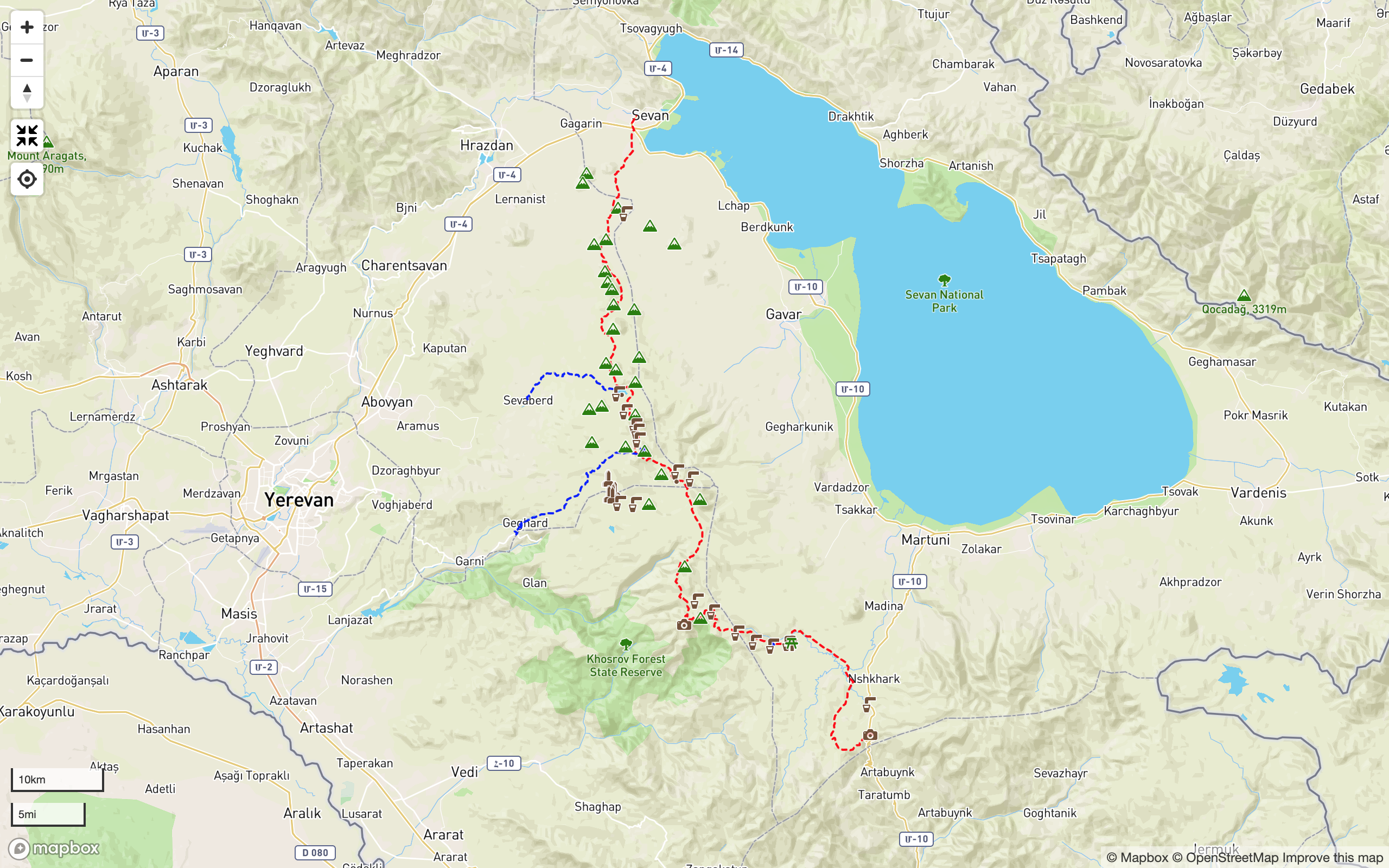
Map & Trail Notes
Quick Facts:
Elevation Min/Avg/Max: 1,921m/2,961m/3,465m
Elevation Gain/Loss: 2,614m/3,022m

Trail Notes
Selim caravanserai (aka: Orbelian caravanserai)
This remote, demanding and utterly spectacular section of the Transcaucasian Trail begins at a place that has been hosting weary travellers for almost 700 years – the early 14th-century caravanserai traditionally known as Selim and still referred to as such by most locals and in a large canon of literature. (Its modern-day renaming to Orbelian caravanserai – apparently an attempt to erase traces of Islamic influence from the site – refers to the ruling Orbeli dynasty who commissioned it in 1328.)
When the caravanserai was established, this region was part of the southwestern khanate (ie: kingdom) of the Mongol Empire which encompassed much of present-day Iran, Turkey and the Caucasus. While these imperial boundaries were in a constant state of flux, the mercantile road network now known as the Silk Road never lost its significance. Caravanserais were built in strategic locations across the Lesser Caucasus Mountains; this one on an important mountain pass between the trading centers of Jugha (Jolfa) and Tiflis (Tbilisi).
Restored in the 1950s, the dark basalt structure’s well-preserved interior evokes images of pack animals stabled along the central nave, being fed and watered from stone troughs, with travellers storing their wares and bedding down in the many side alcoves. The single small entrance was a deliberate feature to make the defence of the building easier from within. Outside, the views south across Vayots Dzor province from just below the pass are nothing short of spectacular.
The caretaker of the site sells local produce from a stall in the parking area during the tourist season, and is usually happy to allow camping in the area surrounding the site (though it’s polite to ask if he is there when you arrive). There are no toilet facilities, though there is a picnic bench and a trash can. A freshwater spring can be found by crossing the road behind the building and walking a little way uphill and E. If this source is dry, another water source connected to an underground cistern can be found by following the suggested trail route about 500m SW along the dirt track from the paved road over the pass itself. Adventurous travellers have also reported bivvying inside the caravanserai itself.
The Argichi floodplain
Our suggested route follows 4×4 tracks along the ridgeline W from the Selim Pass (aka: Vardenyats Pass), with breathtaking views south into Vayots Dzor, before bearing north and descending towards the expansive floodplain of the Argichi river and its tributaries. This fertile, grassy plateau lies at an elevation of 2,200–2,300m and is characterised by its slow-flowing, meandering rivers and wetlands.
These flatlands are a major source of hay production for the villages in the area, so if you’re hiking during high summer, you’re likely to meet plenty of locals making temporary camps in the fields for haymaking season.
The route requires you to cross the Gayladzor, Argichi and Nazarkhane rivers, making use of two shallow vehicle-passable fords and one road bridge. Caution during these river crossings is advised, particularly after rain and during the spring thaw.
W of Mt. Armaghan – a prominent, isolated volcanic cone near the village of Madina – the route begins to penetrate the SE foothills of the Geghama range, climbing and following a low spur into the hills. The short side trail SW shown on the map will bring you to a (locally) well-known natural mineral water spring, complete with a stone picnic table and space for a couple of tents.
The Southern Geghama Range
Following the 4×4 track along the hillsides above the Nazarkhane river will see you gradually gaining elevation, until the route breaks off the 4×4 track. Here it is necessary to hike cross-country and along livestock trails to climb W out of the valley and up to a small plateau at 2,800m in elevation. A reliable spring can be found in one of the gullies on the way up – its precise location is displayed on the map and in the GPS data. If you can’t find it, continue up to flatter ground and ask at the nomad camp.
The route follows little-used 4×4 tracks on the E side of the main Geghama ridgeline before climbing up to the ridge itself. You’ll traverse W via the peak of Mt. Tsaghkavet (3,093m) as the impressive Khachadzor (‘Cross Canyon’) gorge of Khosrov Forest State Reserve come into view. The most spectacular viewpoint of all lies just SW of the suggested route on the tip of a prominent spur, from where almost all of the reserve, much of Ararat province and a good swathe of eastern Turkey (including Mt. Ararat) can be seen on a clear day.
From this point, head N to reach the abandoned ruins of an improbably remote Soviet-era military base. Its location becomes more understandable when you consider that it overlooks what was once the border of the USSR with Turkey and Iran. Below, in the valley to the N, is a dirt road that crosses the drainage divide between the Ararat plains to the W and the Sevan basin to the E. Cross the dirt road and climb N up the other side, following livestock trails up the narrow side valley and ascending to the small ridge below Mt. Ughtasar (not to be confused with the mountain of the same name in Vayots Dzor with its famous petroglyphs).
Pokr & Mets Spitakasar mountains
A narrow trail used by horseback riders and herders traverses the W and N flanks of Pokr Spitakasar (‘Little White Mountain’, 3,485m), avoiding the sheer cliffs below. The peak itself is a non-technical climb and a relatively easy summit in good weather, less than 200m of ascent from the highest point on the trail. Several nomad camps to the NW are visible from this vantage point. The route then descends the lower north-facing slopes of the mountain. The trail becomes less defined at this point but picking a suitable line of descent is relatively simple, leading you down to the expansive grassy steppe that characterises this central, highest and most remote part of the range.
Follow the 4×4 tracks N across open land, staying W of the next prominent peak, Mets Spitakasar (‘Great White Mountain’, 3,555m), characterised on its W side by its distinctive rows of stratified rock columns. Mets Spitakasar is, once again, a relatively simple, non-technical summit opportunity in good weather, though the suggested route of the trail passes along its base. Just NW of the foot of the mountain you will again find yourself following the watershed line, with a dramatic view E down the rocky valley of the upper Gavar river towards the S end of Lake Sevan.
Head down and traverse NW along the southern rim of the picturesque crater containing Badi Lich (‘Duck Lake’). The lakeside itself is a relatively sheltered and pleasant place to camp, though the water of the lake should be treated before drinking as it is frequented by livestock. The red-coloured volcano to the W, Mt. Nazeli (a girl’s name in Armenian and Turkish roughly equivalent to ‘Grace’, 3,312m), is typical of the central Geghama mountains in appearance. Continue NW across open land towards where Mt. Azhdahak, the highest peak in the whole range, should now be clearly visible.
Mount Azhdahak
Ascending Mt. Azhdahak (3,579m) from the southern side first requires a non-technical scramble up the boulder-strewn hillside below Kamurch (‘Bridge’), as the area between Azhdahak (NE) and Tar (SW) is known. Our suggested route follows a gentle gradient across the boulder field and up onto the lava flow SW of the main peak.
We recommend reusing existing trails where possible in order to avoid damaging this extremely sensitive and delicate habitat. The same advice applies to the (optional) final ascent to the peak of Azhdahak itself.
Water from the snowmelt lake within Azhdahak crater is generally considered potable. Swimming in it is generally considered very refreshing! The crater rim makes for a very pleasant loop hike if time allows, with expansive panoramic views in all directions.
The descent N takes place from the same point on the ‘bridge’ below and to the SW of the peak itself, heading roughly W and down through volcanic scree and boulders.
The Aghusar mountains & Lake Akna
As the slope begins to flatten, bear N and traverse around the base of the mountain to the 4×4 track along the valley floor. Following the track and the stream NE for a short distance, passing a small lake (water not potable), then continuing N and up along livestock trails between the twin peaks of East and West Aghusar. Pass between the mountains and to the W of the third peak (Mt. Aghusar itself), from where the significant expanse of Lake Akna should be visible.
The shallow crater lake of Akna (‘Eye’) is the largest body of water in the Geghama range by surface area, and is on the Armenian government’s official list of state-protected natural monuments. Our suggested route from Azhdahak avoids several nomad camps in the area (and thus the possibility of aggressive dog encounters) to bring you to the lake’s northern shore – in high summer, perhaps the only place in the area you’re likely to meet local hikers and campers.
As with most other lakes in the range, water should be treated before drinking due to the presence of livestock herds in the area.
The Northern Geghama Range
North of Lake Akna, the route gradually descends as it weaves between the domed peaks of Karaganchal, Shishdebe, Kermesdepe, Mazaz, Tas, and several others. Like many of the mountains in the range, these peaks bear both an Armenian name and an alternative Kurdish name reflecting the presence of the Yezidi tribe in the region. Most nomad camps remain populated by ethnic Yezidis who speak a Kurdish dialect and still use their own traditional names, even if the peaks have different ‘official’ names. (Often the Armenian and Yezidi names will be direct translations of each other, but this is not always the case.)
In dry years and later in the summer it can be difficult to find reliable water sources on this section of the route. While nomad camps will always supply water or point you towards the nearest source, we recommend treating enough drinking water from Akna Lake for the duration of the final hike to Lchashen if in any doubt. In a pinch, small man-made reservoirs and meltwater pools can usually be located on the map, but usually require a detour from the suggested route.
The final stretch to Lchashen takes place mostly on established 4×4 tracks, the land becoming ever more cultivated as you descend below 2,000m and approach civilization. Congratulations: you have just completed one of the most demanding sections of the Transcaucasian Trail in Armenia!
Menu
Downloads
Apps
Find this trail on following apps and platforms (links open in new tabs):
Partners & Sponsors
This section of the Transcaucasian Trail was developed between 2016-2018 with the support of the following organizations, as well as individual donors to the Transcaucasian Trail Association.
To become a TCTA member and support more trail development projects like this one, join here.
